IMAGES TAKEN NEAR TO
St. Georges Close, WARMINSTER, BA12 9ES
Introduction
This page details the photographs taken nearby to St. Georges Close, BA12 9ES by members of the Geograph project.
The Geograph project started in 2005 with the aim of publishing, organising and preserving representative images for every square kilometre of Great Britain, Ireland and the Isle of Man.

There are currently over 7.5m images from over14,400 individuals and you can help contribute to the project by visiting https://www.geograph.org.uk
Image Map
Images are licensed for reuse under creativecommons.org/licenses/by-sa/2.0
Notes
- Clicking on the map will re-center to the selected point.
- The higher the marker number, the further away the image location is from the centre of the postcode.
Image Listing (10 Images Found)
Images are licensed for reuse under creativecommons.org/licenses/by-sa/2.0
Image
Details
Distance
1

2010 : Woodcock Road, Warminster
At the junction with Heronslade, seen left, mostly residential at this end.
Joins the B3414 about 200 yards on.
Image: © Maurice Pullin
Taken: 22 May 2010
0.09 miles
2
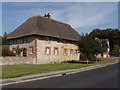
Thatched house in Boreham, Warminster
On west side of Woodcock Road, near junction with Boreham Road.
Image: © David Hawgood
Taken: 10 Sep 2006
0.10 miles
3
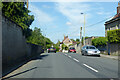
B3414 Boreham Road
Towards the centre of Warminster. The old route of the A36 before a bypass was built.
Image: © Robin Webster
Taken: 30 May 2021
0.14 miles
4
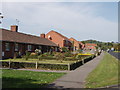
Boreham, Warminster
Houses on the south-west side of Woodcock Road, photo taken from the end of Boreham Field.
Image: © David Hawgood
Taken: 10 Sep 2006
0.14 miles
5

2010 : B3414 at the bottom of Woodcock Road
Bishopstrow Road is opposite.
Right into Warminster, left to Norton Bavant and Heytesbury.
Image: © Maurice Pullin
Taken: 22 May 2010
0.15 miles
6
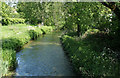
2010 : River Wylye, between Bishopstrow and Boreham
East of Warminster, looking downstream toward Norton Bavant.
Image: © Maurice Pullin
Taken: 22 May 2010
0.16 miles
7
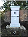
Old Milepost by the B3414, Boreham Road. Boreham
Cast iron post by the B3414, in parish of WARMINSTER (WEST WILTSHIRE District), Boreham Road; 30m North West of the junction with Bishopstrow Road, on the verge, on South-West side of road. C & M Classical iron casting erected by the Warminster Turnpike Trust in the 19th century.
Inscription reads:-
SALISBURY
20
WARMINSTER
1
WARMINSTER
Grade II Listed. List Entry Number: 1364457
https://historicengland.org.uk/listing/the-list/list-entry/1364457
Milestone Society National ID: WI_SAWM20.
N.B. The post was excavated in 2017 in connection with a planning application and beautifully restored by Wessex Archaeology http://www.wessexarch.co.uk/ and when excavated was found to have an older generation milestone underneath it as a base - see Image
Image: © Milestone Society
Taken: 28 Feb 2017
0.16 miles
8
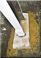
Old Milestone by the B3414, Boreham Road, Boreham
When Image was being excavated by Wessex Archaeology https://www.wessexarch.co.uk/ a remarkable discovery was made. Underneath the post was an earlier stone, used as a base. Probably early 19th century.
Inscription reads:- : To / Warminster / To(wn Ha)ll / H(alf) a Mile (S)arum / 20 Miles :
Milestone Society National ID: WI_SAWM20A.
Image: © Milestone Society
Taken: 28 Feb 2017
0.16 miles
9
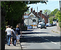
2010 : B3414 with walkers entering Warminster
They have a choice of venue for refreshments, they could call at the garage for a fill-up or the could go the extra yard and visit the Yew Tree. Marston's, a good Burton name.
Image: © Maurice Pullin
Taken: 22 May 2010
0.16 miles
10
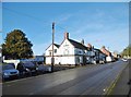
Boreham, Yew Tree
Public house on Boreham Road; according to a sign, once the Coach & Horses Tavern, 1878.
Image: © Mike Faherty
Taken: 28 Feb 2017
0.20 miles