IMAGES TAKEN NEAR TO
Robin Close, WARMINSTER, BA12 9DE
Introduction
This page details the photographs taken nearby to Robin Close, BA12 9DE by members of the Geograph project.
The Geograph project started in 2005 with the aim of publishing, organising and preserving representative images for every square kilometre of Great Britain, Ireland and the Isle of Man.

There are currently over 7.5m images from over14,400 individuals and you can help contribute to the project by visiting https://www.geograph.org.uk
Image Map
Images are licensed for reuse under creativecommons.org/licenses/by-sa/2.0
Notes
- Clicking on the map will re-center to the selected point.
- The higher the marker number, the further away the image location is from the centre of the postcode.
Image Listing (65 Images Found)
Images are licensed for reuse under creativecommons.org/licenses/by-sa/2.0
Image
Details
Distance
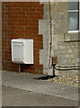
1
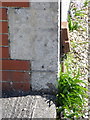
Bench Mark, Woodcock Road
The bench mark is to be found on No 53 Woodcock Road. For a wider view Image and for further information on the bench mark and others in the area http://www.bench-marks.org.uk/bm37289
Image: © Maigheach-gheal
Taken: 14 Mar 2011
0.04 miles
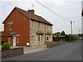
2
No 53 Woodcock Road, Warminster
There is an Ordnance Survey bench mark on the angle of the nearest house.
Image: © Maigheach-gheal
Taken: 14 Mar 2011
0.04 miles
3
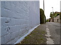
Blue benchmark
A cutmark, as listed in the Benchmark Database: http://www.bench-marks.org.uk/bm37289 , low down on a wall along Woodcock Lane.
Image: © Neil Owen
Taken: 27 Sep 2013
0.05 miles
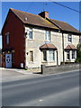
4
Woodcock Road
An older house compared to those that now spring up beside it. A benchmark can be seen on the corner - Image
Image: © Neil Owen
Taken: 27 Sep 2013
0.06 miles
5
Benchmark on Woodcock Road
A cutmark, as listed in the Benchmark Database: http://www.bench-marks.org.uk/bm52863 , on the corner of a house. See Image] for a wider view.
Image: © Neil Owen
Taken: 27 Sep 2013
0.06 miles
6

New Close Community Primary School, Warminster
Viewed from Woodcock Lane.
Image: © Jaggery
Taken: 9 May 2014
0.09 miles
7
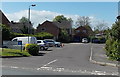
Imberwood Close, Warminster
Viewed from Woodcock Road.
Image: © Jaggery
Taken: 9 May 2014
0.10 miles
8
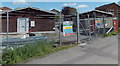
Military buildings in Woodcock Lane, Warminster
Located in a fenced compound topped with razor wire are
an Army Cadet Force hut on the left and an Air Training Corps hut on the right.
Image: © Jaggery
Taken: 9 May 2014
0.11 miles
9
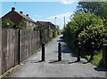
Blocked off Woodcock Lane, Warminster
Black metal posts prevent vehicular access beyond
the entrance http://www.geograph.org.uk/photo/4055181 to New Close Community Primary School.
Image: © Jaggery
Taken: 9 May 2014
0.11 miles
10
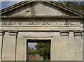
Mors Janua Vitae
Or translated as 'Death is the gateway to (everlasting) life'. The small yard adjoining St George's church features this imposing motto. See Image] for a look at the details in the ironwork of the railings in front of it.
Image: © Neil Owen
Taken: 2 May 2013
0.11 miles