IMAGES TAKEN NEAR TO
Imber Road, WARMINSTER, BA12 9DD
Introduction
This page details the photographs taken nearby to Imber Road, BA12 9DD by members of the Geograph project.
The Geograph project started in 2005 with the aim of publishing, organising and preserving representative images for every square kilometre of Great Britain, Ireland and the Isle of Man.

There are currently over 7.5m images from over14,400 individuals and you can help contribute to the project by visiting https://www.geograph.org.uk
Image Map
Images are licensed for reuse under creativecommons.org/licenses/by-sa/2.0
Notes
- Clicking on the map will re-center to the selected point.
- The higher the marker number, the further away the image location is from the centre of the postcode.
Image Listing (125 Images Found)
Images are licensed for reuse under creativecommons.org/licenses/by-sa/2.0
Image
Details
Distance
1
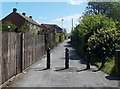
Blocked off Woodcock Lane, Warminster
Black metal posts prevent vehicular access beyond
the entrance http://www.geograph.org.uk/photo/4055181 to New Close Community Primary School.
Image: © Jaggery
Taken: 9 May 2014
0.02 miles
2
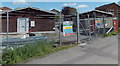
Military buildings in Woodcock Lane, Warminster
Located in a fenced compound topped with razor wire are
an Army Cadet Force hut on the left and an Air Training Corps hut on the right.
Image: © Jaggery
Taken: 9 May 2014
0.02 miles
3
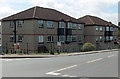
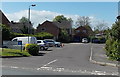
Imber Road flats, Warminster
Near the corner of Woodcock Road.
Image: © Jaggery
Taken: 9 May 2014
0.02 miles
4
Lyons Seafoods in Warminster
Seafood processing business on the corner of Fairfield Road and Imber Road.
Arrows direct you left for reception and the visitors' car park, right for the main gate and goods in/out.
Image: © Jaggery
Taken: 9 May 2014
0.03 miles
5
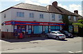
Imber Road One Stop Shop in Warminster
The shop at 26-28 Imber Road is opposite the Fairfield Road junction.
Text on the nameboard states that the shop is open every day from 6am to 11pm.
Image: © Jaggery
Taken: 9 May 2014
0.03 miles
6
Imberwood Close, Warminster
Viewed from Woodcock Road.
Image: © Jaggery
Taken: 9 May 2014
0.04 miles
7

New Close Community Primary School, Warminster
Viewed from Woodcock Lane.
Image: © Jaggery
Taken: 9 May 2014
0.04 miles
8
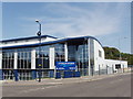
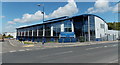
Shellfish and prawn processing plant, Warminster
Lyons Seafood in Warminster employs 300 people in this new purpose-built plant. Much of the business is processing prawns from the Far East into forms and packaging suitable for retailers and food manufacturers.
Image: © David Hawgood
Taken: 10 Sep 2006
0.05 miles
9

Fox Auto Repairs and SW Valeting in Warminster
Servicing & repairs business, and hand car wash, in Woodcock Road.
Image: © Jaggery
Taken: 9 May 2014
0.07 miles
10
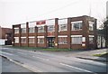
Former Art Deco/Modernist Offices, Fairfield Road, Warminster, Wiltshire
This Art Deco/Modernist administrative block belonged to Dents the glove makers until it was demolished in 2011. Established in Worcester in 1777, Dents moved to Warminster in the 1937 when it took over the former Jefferies Manufacturing Company premises. One commentator recalls the new building being erected in the early fifties. This was quite possible, as it was common to find pre-war designs built after the war ended (Dorchester Council Offices being an example). In 2011 Dents moved to larger premises on the outskirts of the town, off the Bath Road. The site was sold to Waitrose who demolished the whole site including the building. As at late 2011 the new supermarket is under construction. Despite Art Deco/Modernist buildings being few in number in Wiltshire, the council were not minded to protect it.
Image: © Alan Cooper
Taken: Unknown
0.09 miles