IMAGES TAKEN NEAR TO
Woodman Mead, WARMINSTER, BA12 8TE
Introduction
This page details the photographs taken nearby to Woodman Mead, BA12 8TE by members of the Geograph project.
The Geograph project started in 2005 with the aim of publishing, organising and preserving representative images for every square kilometre of Great Britain, Ireland and the Isle of Man.

There are currently over 7.5m images from over14,400 individuals and you can help contribute to the project by visiting https://www.geograph.org.uk
Image Map
Images are licensed for reuse under creativecommons.org/licenses/by-sa/2.0
Notes
- Clicking on the map will re-center to the selected point.
- The higher the marker number, the further away the image location is from the centre of the postcode.
Image Listing (124 Images Found)
Images are licensed for reuse under creativecommons.org/licenses/by-sa/2.0
Image
Details
Distance
1
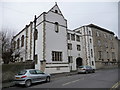
Warminster - Theological College
This former nunnery is now part of St Boniface Theological College.
Image: © Chris Talbot
Taken: 31 Jan 2009
0.14 miles
2
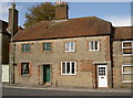
The start of West Street
A half hip-ended house marks the beginning of the street from Vicarage Street.
Image: © Neil Owen
Taken: 7 Oct 2014
0.14 miles
3
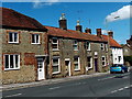
From West Street to Vicarage Street, Warminster
Viewed from the northern end of Pound Street. The West Street name sign is on the wall
of the house on the left. The Vicarage Street name sign is on the house next door.
Image: © Jaggery
Taken: 9 May 2014
0.14 miles
4
Old orphanage
West Street was home to a number of sites for the Orphanage of Pity. Moving from neighbouring properties into West House in 1872, the new house afforded accommodation for twenty-two girls. The boys were homed next door. The charity was entirely self-funded and as a consequence struggled at times, but somehow managed to feed and clothe their charges. The number of orphans grew and moved out of West House in 1890.
Image: © Neil Owen
Taken: 7 Oct 2014
0.15 miles
5
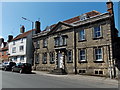
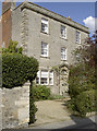
Wren House, Warminster
On the north side of Vicarage Street. A blue plaque states that Wren House
was built c.1720-1730 as an early Georgian clothier's house.
Image: © Jaggery
Taken: 9 May 2014
0.15 miles
6
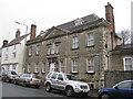
Wren House, Warminster
An early Georgian clothier's house, c.1720-30, with a Venetian window, and a six-panel door with a Gibbs surround Image Now a residential care home.
Image: © M J Richardson
Taken: 25 Dec 2015
0.15 miles
7
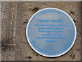
Wren House - blue plaque
On Wren House, Vicarage Street - once a Georgian clothier's house, now a residential care home Image
Image: © M J Richardson
Taken: 25 Dec 2015
0.15 miles
8
Not a military police speed check area, Warminster
A Vicarage Street house has various signs on display.
In addition to the one in the title, a green GOODS DEPOT sign is in the background.
Image: © Jaggery
Taken: 9 May 2014
0.15 miles
9
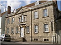
Wren House
Bearing a benchmark on the nearest corner - see Image
Image: © Neil Owen
Taken: 7 Oct 2014
0.16 miles
10
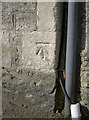
Benchmark on Wren House
As listed in the Benchmark Database: http://www.bench-marks.org.uk/bm61741 , this mark dates from the nineteenth century. See Image] for a wider look at this fine old Georgian house.
Image: © Neil Owen
Taken: 7 Oct 2014
0.16 miles