IMAGES TAKEN NEAR TO
Bath Road, WARMINSTER, BA12 8PB
Introduction
This page details the photographs taken nearby to Bath Road, BA12 8PB by members of the Geograph project.
The Geograph project started in 2005 with the aim of publishing, organising and preserving representative images for every square kilometre of Great Britain, Ireland and the Isle of Man.

There are currently over 7.5m images from over14,400 individuals and you can help contribute to the project by visiting https://www.geograph.org.uk
Image Map
Images are licensed for reuse under creativecommons.org/licenses/by-sa/2.0
Notes
- Clicking on the map will re-center to the selected point.
- The higher the marker number, the further away the image location is from the centre of the postcode.
Image Listing (23 Images Found)
Images are licensed for reuse under creativecommons.org/licenses/by-sa/2.0
Image
Details
Distance


6
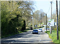
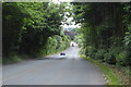
2010 : B3414 Bath Road north west out of Warminster
Formerly the A36 before Warminster was bypassed.
Image: © Maurice Pullin
Taken: 17 Apr 2010
0.09 miles
7

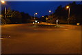
Crusader Park, Warminster
Looking north along Roman Way at Crusader Park, Warminster.
Image: © Phil Williams
Taken: 27 Nov 2005
0.10 miles
9

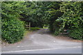
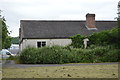
2010 : Council depot, Furnax Lane
A reminder that this grid square is not all about pretty houses, it has its practical side as well.
Warminster Depot is well guarded, the re-cycling centre is a bit further on.
Image: © Maurice Pullin
Taken: 17 Apr 2010
0.13 miles