IMAGES TAKEN NEAR TO
Alcock Crest, WARMINSTER, BA12 8NB
Introduction
This page details the photographs taken nearby to Alcock Crest, BA12 8NB by members of the Geograph project.
The Geograph project started in 2005 with the aim of publishing, organising and preserving representative images for every square kilometre of Great Britain, Ireland and the Isle of Man.

There are currently over 7.5m images from over14,400 individuals and you can help contribute to the project by visiting https://www.geograph.org.uk
Image Map
Images are licensed for reuse under creativecommons.org/licenses/by-sa/2.0
Notes
- Clicking on the map will re-center to the selected point.
- The higher the marker number, the further away the image location is from the centre of the postcode.
Image Listing (84 Images Found)
Images are licensed for reuse under creativecommons.org/licenses/by-sa/2.0
Image
Details
Distance
1
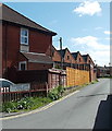
Factory Lane, Warminster
Looking south from the corner of West Parade and Pound Street.
Image: © Jaggery
Taken: 9 May 2014
0.05 miles
2
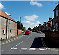
East along West Parade, Warminster
Viewed across Pound Street.
Image: © Jaggery
Taken: 9 May 2014
0.06 miles
3
Blue shutters and grey gables in Warminster
Pound Street houses near the Factory Lane and West Parade junction.
Image: © Jaggery
Taken: 9 May 2014
0.07 miles
4
2010 : Pound Street, Warminster
The pound in this example was probably somewhere where they kept animals.
A row of older terraced houses is seen.
Image: © Maurice Pullin
Taken: 17 Apr 2010
0.08 miles
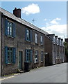
5

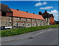
2010 : Terraced cottages in Pound Street, Warminster
It is said that the town is named after the church which stands by the River Were, therefore Wereminster.
Image: © Maurice Pullin
Taken: 17 Apr 2010
0.10 miles
6
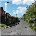
One way traffic along Princecroft Lane, Warminster
The white arrow on a blue background indicates one way traffic away from the Pound Street junction.
Image: © Jaggery
Taken: 9 May 2014
0.11 miles
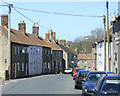
7

Pound Street houses, Warminster
Between Westleigh near the camera and Cobbett Place ahead.
Image: © Jaggery
Taken: 9 May 2014
0.13 miles
8
Cobbett Place, Warminster
Viewed from Pound Street looking east towards The Teasels.
Image: © Jaggery
Taken: 9 May 2014
0.13 miles
9
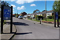
Westleigh Home Zone, Warminster
Viewed from Pound Street. The Wiltshire Council website states that a Home Zone is a street or group
of streets designed primarily to meet the needs of pedestrians or cyclists. This is achieved by turning space previously considered for the motorist (carriageway) into areas that can be shared by both the vehicle and vulnerable road users.
Legally neither the pedestrian nor the motorist has priority over the other. The design should attempt to introduce specific measures to readdress the balance between motor vehicles and the pedestrian.
Image: © Jaggery
Taken: 9 May 2014
0.14 miles
10
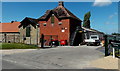
Entrance to Warminster Maltings Ltd
From Cobbett Lane, Warminster. The second line of the name sign shows Traditional Maltsters.
Image: © Jaggery
Taken: 9 May 2014
0.15 miles