IMAGES TAKEN NEAR TO
West Street, WARMINSTER, BA12 8JY
Introduction
This page details the photographs taken nearby to West Street, BA12 8JY by members of the Geograph project.
The Geograph project started in 2005 with the aim of publishing, organising and preserving representative images for every square kilometre of Great Britain, Ireland and the Isle of Man.

There are currently over 7.5m images from over14,400 individuals and you can help contribute to the project by visiting https://www.geograph.org.uk
Image Map
Images are licensed for reuse under creativecommons.org/licenses/by-sa/2.0
Notes
- Clicking on the map will re-center to the selected point.
- The higher the marker number, the further away the image location is from the centre of the postcode.
Image Listing (55 Images Found)
Images are licensed for reuse under creativecommons.org/licenses/by-sa/2.0
Image
Details
Distance
1
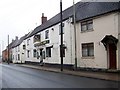
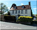
The Cock Inn, Warminster
The inn is on West Street.
Image: © Maigheach-gheal
Taken: 3 Feb 2010
0.00 miles
2

The Cock Inn, Warminster: mid August 2016
Image: © Basher Eyre
Taken: 22 Aug 2016
0.01 miles
3
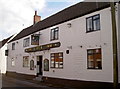
The Cock Inn
One of the older establishments along West Street.
Image: © Neil Owen
Taken: 7 Oct 2014
0.01 miles
4
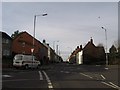
West Street looking towards the west
This photo was taken to compare with an old black and white postcard view taken at the start of the 20th century.
Image: © Robert Wilkinson
Taken: 22 Jan 2008
0.02 miles
5
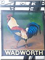
Sign for the Cock Inn
An ancient tavern sign in use since the 14th century. Often an indication in the past that cock fighting took place in the yard. In the 17th century the sign may also have advertised the sale of 'cock-ale' which was 'ale mixed with the jelly of minced meat of a boiled cock, besides other ingredients'.
Image: © Maigheach-gheal
Taken: 3 Feb 2010
0.02 miles
6

Cottages in West Street
A row of old cottages and terraced houses to the west of the town centre. But in the past they were used as a drill hall for the Wiltshire Yeomanry. See http://www.geograph.org.uk/article/WW1-Great-War-Centenary---Drill-Halls/12#wiltshire for a look at the county's halls.
Image: © Neil Owen
Taken: 7 Oct 2014
0.08 miles
7
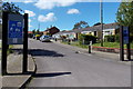
Westleigh Home Zone, Warminster
Viewed from Pound Street. The Wiltshire Council website states that a Home Zone is a street or group
of streets designed primarily to meet the needs of pedestrians or cyclists. This is achieved by turning space previously considered for the motorist (carriageway) into areas that can be shared by both the vehicle and vulnerable road users.
Legally neither the pedestrian nor the motorist has priority over the other. The design should attempt to introduce specific measures to readdress the balance between motor vehicles and the pedestrian.
Image: © Jaggery
Taken: 9 May 2014
0.08 miles
8
Old orphanage
West Street was home to a number of sites for the Orphanage of Pity. Moving from neighbouring properties into West House in 1872, the new house afforded accommodation for twenty-two girls. The boys were homed next door. The charity was entirely self-funded and as a consequence struggled at times, but somehow managed to feed and clothe their charges. The number of orphans grew and moved out of West House in 1890.
Image: © Neil Owen
Taken: 7 Oct 2014
0.08 miles
9
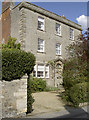
Grade II listed 24 Pound Street, Warminster
The 18th century house facing Cobbett Place was altered in the early-mid 19th century.
Grade II listed in 1952. Why is the central upstairs window different from the other four?
Image: © Jaggery
Taken: 9 May 2014
0.10 miles
10
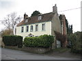
24 Pound Street, Warminster
An imposing 18thC house, just across the road from the maltings [perhaps a manager/owner's residence?]. It has had a makeover since Jaggery was there in May 2014 Image
Image: © M J Richardson
Taken: 26 Dec 2015
0.10 miles