IMAGES TAKEN NEAR TO
South Street, WARMINSTER, BA12 8DS
Introduction
This page details the photographs taken nearby to South Street, BA12 8DS by members of the Geograph project.
The Geograph project started in 2005 with the aim of publishing, organising and preserving representative images for every square kilometre of Great Britain, Ireland and the Isle of Man.

There are currently over 7.5m images from over14,400 individuals and you can help contribute to the project by visiting https://www.geograph.org.uk
Image Map
Images are licensed for reuse under creativecommons.org/licenses/by-sa/2.0
Notes
- Clicking on the map will re-center to the selected point.
- The higher the marker number, the further away the image location is from the centre of the postcode.
Image Listing (21 Images Found)
Images are licensed for reuse under creativecommons.org/licenses/by-sa/2.0
Image
Details
Distance
1
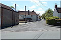
King Street, Warminster
Looking to the SW along King Street from Brook Street.
Image: © Jaggery
Taken: 9 May 2014
0.11 miles
2
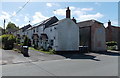
Row of houses, Brook Street, Warminster
The row is aligned at 90 degrees to the roadway.
Image: © Jaggery
Taken: 9 May 2014
0.15 miles
3
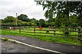
Broadway bungalows in Warminster
Viewed from the corner of Brook Street.
Image: © Jaggery
Taken: 9 May 2014
0.15 miles
4
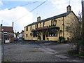
Chapel Lane
A view looking southeast into Chapel Lane, past the Snooty Fox public house from Fore Street.
Image: © Phil Williams
Taken: 2 Apr 2006
0.15 miles
5
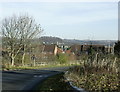
2008 : Bradley Road, Warminster
Looking north east from the bridge over Warminster bypass toward the town centre.
Christ Church is prominent centre frame.
Image: © Maurice Pullin
Taken: 19 Nov 2008
0.17 miles
6
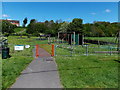
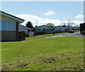
Fore Street Active Play Environment in Warminster
This area contains equipment to encourage physical activity for all ages.
Image: © Jaggery
Taken: 9 May 2014
0.17 miles
7
Warminster : Play Area
A play area seen from Brook Street.
Image: © Lewis Clarke
Taken: 31 Jul 2023
0.17 miles
8
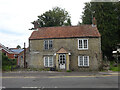
52 Brook Street, Warminster
Thought to be a former Toll House, in the Sambourne area of the town. The 1808 Edmund Crocker map https://britishlibrary.oldmapsonline.org/compare#158464282161 shows 3 "Turnpike gates" but not one at this location. Possibly this location dates from nearer 1845 when Turnpikes started to disappear.
Milestone Society National ID: WI.WAR05
Image: © Mr Red
Taken: 4 Aug 2023
0.18 miles
9
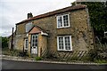
Warminster : House
A house on Brook Street.
Image: © Lewis Clarke
Taken: 31 Jul 2023
0.18 miles
10
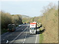
2008 : Warminster bypass from Bradley Road
Looking north west from the bridge on Bradley Road. The bypass was a great relief to Warminster when it came.
Cley Hill rises in the distance ST8344
Image: © Maurice Pullin
Taken: 19 Nov 2008
0.19 miles