IMAGES TAKEN NEAR TO
Cannimore Lane, WARMINSTER, BA12 8DP
Introduction
This page details the photographs taken nearby to Cannimore Lane, BA12 8DP by members of the Geograph project.
The Geograph project started in 2005 with the aim of publishing, organising and preserving representative images for every square kilometre of Great Britain, Ireland and the Isle of Man.

There are currently over 7.5m images from over14,400 individuals and you can help contribute to the project by visiting https://www.geograph.org.uk
Image Map
Images are licensed for reuse under creativecommons.org/licenses/by-sa/2.0
Notes
- Clicking on the map will re-center to the selected point.
- The higher the marker number, the further away the image location is from the centre of the postcode.
Image Listing (7 Images Found)
Images are licensed for reuse under creativecommons.org/licenses/by-sa/2.0
Image
Details
Distance
1
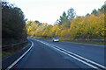
A36 towards Bath
Bypassing Warminster.
Image: © Robin Webster
Taken: 13 Nov 2022
0.08 miles
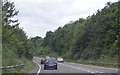
3
2009 : A36 Warminster bypass
Looking east toward Heytesbury, about 3 miles further on.
Image: © Maurice Pullin
Taken: 25 Jul 2009
0.16 miles
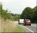
4

Sambourne, lay-by
On A350 Southbound. Gritters have been out, and the snow is not expected to stay.
Image: © Mike Faherty
Taken: 18 Mar 2018
0.16 miles
5
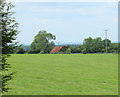
2010 : Rusty roof seen from Bradley Road
Over a pasture near Botany Farm.
Corrugated iron makes good roofing material as on this barn, but it does have a limited shelf life.
Image: © Maurice Pullin
Taken: 21 Jun 2010
0.18 miles
6

A36 lay by east of Cannimore road overbridge
Image: © John Firth
Taken: 11 Apr 2013
0.18 miles
7

Folly Lane - looking east towards Warminster
The road is a dead end since the building of the Warminster by-pass in the 1980's.
It now serves Warminster Rugby Club and Folly Farm.
Image: © Jonathan Billinger
Taken: 15 Jan 2009
0.24 miles