IMAGES TAKEN NEAR TO
Bradley Road, WARMINSTER, BA12 8BN
Introduction
This page details the photographs taken nearby to Bradley Road, BA12 8BN by members of the Geograph project.
The Geograph project started in 2005 with the aim of publishing, organising and preserving representative images for every square kilometre of Great Britain, Ireland and the Isle of Man.

There are currently over 7.5m images from over14,400 individuals and you can help contribute to the project by visiting https://www.geograph.org.uk
Image Map
Images are licensed for reuse under creativecommons.org/licenses/by-sa/2.0
Notes
- Clicking on the map will re-center to the selected point.
- The higher the marker number, the further away the image location is from the centre of the postcode.
Image Listing (17 Images Found)
Images are licensed for reuse under creativecommons.org/licenses/by-sa/2.0
Image
Details
Distance
1
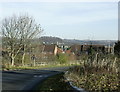
2008 : Bradley Road, Warminster
Looking north east from the bridge over Warminster bypass toward the town centre.
Christ Church is prominent centre frame.
Image: © Maurice Pullin
Taken: 19 Nov 2008
0.11 miles
2
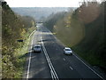
2008 : Road bridge on Bradley Road, Warminster
Overlooking the A36 Warminster bypass looking south east.
Image: © Maurice Pullin
Taken: 19 Nov 2008
0.17 miles
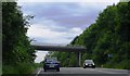
4
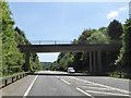
Bradley Road bridge over A36 near Warminster
Image: © David Smith
Taken: 1 Jun 2017
0.19 miles
5
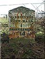
Old Milestone by Deverill Road, Warminster parish
Metal plate attached to stone post by the UC road, in parish of WARMINSTER (WEST WILTSHIRE District), Deverill Road; opposite No. 124 (farm cottage), on the verge, on East side of road. Warminster plate, erected by the Warminster turnpike trust in the 19th century.
Inscription reads:-
WARMINSTER
TOWN.HALL
1
SHAFTESBURY
14
----
KNOYLE 9.
Milestone Society National ID: WI_WMSH01.
Image: © M Faherty
Taken: 10 Mar 2007
0.20 miles
6
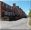
Chapel Street, Warminster
Looking WNW from the Bread Street junction.
Image: © Jaggery
Taken: 9 May 2014
0.20 miles
7

Junction of Chapel Street and Bread Street, Warminster
Viewed from Chapel Street. The No Entry sign is in Bread Street.
Image: © Jaggery
Taken: 9 May 2014
0.20 miles
8
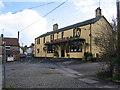
Chapel Lane
A view looking southeast into Chapel Lane, past the Snooty Fox public house from Fore Street.
Image: © Phil Williams
Taken: 2 Apr 2006
0.20 miles
9
Satellite dishes in Chapel Street, Warminster
On the right, five dishes on the brick walls of houses
and one on a stone house wall behind a post, two more on the left.
Image: © Jaggery
Taken: 9 May 2014
0.20 miles
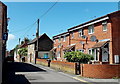
10

Chapel Street, Warminster
Viewed from the Deverill Road end looking towards Bread Street.
Image: © Jaggery
Taken: 9 May 2014
0.21 miles