IMAGES TAKEN NEAR TO
Crockerton, WARMINSTER, BA12 8AU
Introduction
This page details the photographs taken nearby to BA12 8AU by members of the Geograph project.
The Geograph project started in 2005 with the aim of publishing, organising and preserving representative images for every square kilometre of Great Britain, Ireland and the Isle of Man.

There are currently over 7.5m images from over14,400 individuals and you can help contribute to the project by visiting https://www.geograph.org.uk
Image Map
Images are licensed for reuse under creativecommons.org/licenses/by-sa/2.0
Notes
- Clicking on the map will re-center to the selected point.
- The higher the marker number, the further away the image location is from the centre of the postcode.
Image Listing (7 Images Found)
Images are licensed for reuse under creativecommons.org/licenses/by-sa/2.0
Image
Details
Distance
1
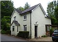
Old Toll House, Crockerton
Crockerton Toll House by the UC road (was A350), in parish of Longbridge Deverill (West Wiltshire District), tollhouse, Parson's Lane junction.
Surveyed
Milestone Society National ID: WI.LON
Image: © Alan Rosevear
Taken: 24 Jun 2013
0.09 miles
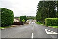
2
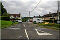
Longbridge Deverill : Crockerton - Bull Lane
Bull Lane off the A350.
Image: © Lewis Clarke
Taken: 31 Jul 2023
0.09 miles
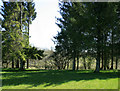
3
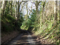
Dry Hill, Crockerton Green
A sunken lane typical of sandstone, which also probably accounts for the name of the hill.
Image: © Robin Webster
Taken: 2 Mar 2017
0.14 miles
4
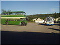
Crockerton Garden Centre Car Park
The car park at Crockerton Garden Centre, here occupied by a Bath Services Lodekka and Ulsterbus Bristol RE on Warminster Vintage Bus Running Day.
Image: © David Roberts
Taken: 14 Sep 2003
0.23 miles
5
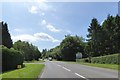
A350 bypassing Crockerton
The sign on the right points to a garden centre and linked businesses
Image: © David Smith
Taken: 1 Jun 2017
0.23 miles
6
Longbridge Deverill : Crockerton - Road
A road to Crockerton Warehouse and Lakeside Garden Centre.
Image: © Lewis Clarke
Taken: 31 Jul 2023
0.24 miles
7
2010 : East from a minor road through Crockerton
Image: © Maurice Pullin
Taken: 17 Apr 2010
0.25 miles