IMAGES TAKEN NEAR TO
Potters Hill, WARMINSTER, BA12 8AD
Introduction
This page details the photographs taken nearby to Potters Hill, BA12 8AD by members of the Geograph project.
The Geograph project started in 2005 with the aim of publishing, organising and preserving representative images for every square kilometre of Great Britain, Ireland and the Isle of Man.

There are currently over 7.5m images from over14,400 individuals and you can help contribute to the project by visiting https://www.geograph.org.uk
Image Map
Images are licensed for reuse under creativecommons.org/licenses/by-sa/2.0
Notes
- Clicking on the map will re-center to the selected point.
- The higher the marker number, the further away the image location is from the centre of the postcode.
Image Listing (5 Images Found)
Images are licensed for reuse under creativecommons.org/licenses/by-sa/2.0
Image
Details
Distance
1

Christ Church, Crockerton glimpsed above some horses
The church has been an art studio since 1973 https://history.wiltshire.gov.uk/community/getchurch.php?id=784
Image: © Basher Eyre
Taken: 26 Aug 2016
0.06 miles
2
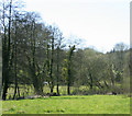
2010 : Pasture and well developed hedgerow, Crockerton
Looking west in the direction of Shear Water.
Image: © Maurice Pullin
Taken: 17 Apr 2010
0.20 miles
3
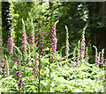
2010 : Digitalis purpurea, Common Foxglove
In a pine plantation north of Crockerton.
"The scientific name means "finger-like" and refers to the ease with which a flower of Digitalis purpurea can be fitted over a human fingertip."
Copied from: http://en.wikipedia.org/wiki/Digitalis where there is much more.
Image: © Maurice Pullin
Taken: 21 Jun 2010
0.20 miles
4
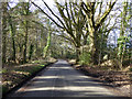
The Red Way
A wood called Corp's Clump is on the left.
Image: © Robin Webster
Taken: 2 Mar 2017
0.22 miles
5
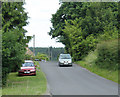
2010 : Looking east on Clay Street, Crockerton
Once over the brow of the hill the road drops toward Crockerton.
Image: © Maurice Pullin
Taken: 21 Jun 2010
0.24 miles