IMAGES TAKEN NEAR TO
Folly Lane, WARMINSTER, BA12 7RQ
Introduction
This page details the photographs taken nearby to Folly Lane, BA12 7RQ by members of the Geograph project.
The Geograph project started in 2005 with the aim of publishing, organising and preserving representative images for every square kilometre of Great Britain, Ireland and the Isle of Man.

There are currently over 7.5m images from over14,400 individuals and you can help contribute to the project by visiting https://www.geograph.org.uk
Image Map
Images are licensed for reuse under creativecommons.org/licenses/by-sa/2.0
Notes
- Clicking on the map will re-center to the selected point.
- The higher the marker number, the further away the image location is from the centre of the postcode.
Image Listing (7 Images Found)
Images are licensed for reuse under creativecommons.org/licenses/by-sa/2.0
Image
Details
Distance
4
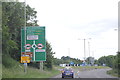
Warminster : A36
Looking along the A36.
Image: © Lewis Clarke
Taken: 31 Jul 2023
0.13 miles
5
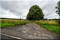
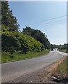
Warminster : Track
A track off the A362.
Image: © Lewis Clarke
Taken: 31 Jul 2023
0.14 miles
6

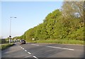
2009 : A36 Warminster bypass with a view of Cley Hill
It is to the credit of those involved in the building and maintenance of this bypass that most of it is hidden by trees.
Cley Hill is at Image
Image: © Maurice Pullin
Taken: 25 Jul 2009
0.16 miles
7
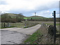
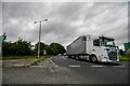
Bridle Path from Bugley
A view looking northwest at the start of a bridleway at Bugley. The A36 Warminster By-pass can be seen in the middle distance with Cley Hill in the background at left.
Image: © Phil Williams
Taken: 2 Apr 2006
0.21 miles