IMAGES TAKEN NEAR TO
Whitbourne Springs, WARMINSTER, BA12 7RF
Introduction
This page details the photographs taken nearby to Whitbourne Springs, BA12 7RF by members of the Geograph project.
The Geograph project started in 2005 with the aim of publishing, organising and preserving representative images for every square kilometre of Great Britain, Ireland and the Isle of Man.

There are currently over 7.5m images from over14,400 individuals and you can help contribute to the project by visiting https://www.geograph.org.uk
Image Map
Images are licensed for reuse under creativecommons.org/licenses/by-sa/2.0
Notes
- Clicking on the map will re-center to the selected point.
- The higher the marker number, the further away the image location is from the centre of the postcode.
Image Listing (5 Images Found)
Images are licensed for reuse under creativecommons.org/licenses/by-sa/2.0
Image
Details
Distance
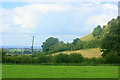
1
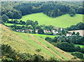
2008 : Whitbourne Springs from Cley Hill summit
On the A362 Frome to Warminster road.
Image: © Maurice Pullin
Taken: 21 Aug 2008
0.02 miles
2
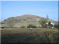
Cley Hill
A view looking north to Cley Hill from the parking area adjacent to the A362. The footpath leading to the hill can be seen at right.
Image: © Phil Williams
Taken: 5 Feb 2006
0.22 miles
3
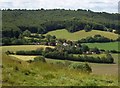
The village of Sturtford from Cley Hill
The village of Sturtford to the West of Cley Hill.
Image: © Len Williams
Taken: 10 Jun 2011
0.23 miles
4
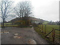
December gloom
Cley hill viewed from the National Trust Car park.
A hill fort is situated around the summit.
In the 60/70's the area was a ' hot spot ' for UFO activity.
Image: © Anthony Vosper
Taken: 1 Dec 2018
0.24 miles
5
2008 : View from Cley Hill car park
The car park on the A362 is not signposted and is easily missed. When approaching from the east look for the roundabout at Picket Post Gate, the car park is about 500 M. further on the right.
Image: © Maurice Pullin
Taken: 21 Aug 2008
0.24 miles