IMAGES TAKEN NEAR TO
Tascroft, WARMINSTER, BA12 7RA
Introduction
This page details the photographs taken nearby to Tascroft, BA12 7RA by members of the Geograph project.
The Geograph project started in 2005 with the aim of publishing, organising and preserving representative images for every square kilometre of Great Britain, Ireland and the Isle of Man.

There are currently over 7.5m images from over14,400 individuals and you can help contribute to the project by visiting https://www.geograph.org.uk
Image Map
Images are licensed for reuse under creativecommons.org/licenses/by-sa/2.0
Notes
- Clicking on the map will re-center to the selected point.
- The higher the marker number, the further away the image location is from the centre of the postcode.
Image Listing (4 Images Found)
Images are licensed for reuse under creativecommons.org/licenses/by-sa/2.0
Image
Details
Distance
1
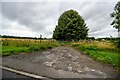
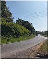
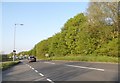
Warminster : Track
A track off the A362.
Image: © Lewis Clarke
Taken: 31 Jul 2023
0.20 miles
4
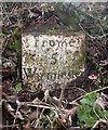
Old Milestone by the A362, west of Warminster
Metal plate attached to stone post by the A362, in parish of Warminster (West Wiltshire District), Picket Post Gate; 375m East of gate, in base of hedgerow. Frome iron plate, erected by the Frome turnpike trust in the 18th century.
Inscription reads:-
Frome
5
Warminster
2
Large carved mark and rivet benchmark on top.
Grade II listed.
List Entry Number: 1036257 https://historicengland.org.uk/listing/the-list/list-entry/1036257
Milestone Society National ID: WI_WMFR02
Image: © M Faherty
Taken: 10 Mar 2007
0.25 miles