IMAGES TAKEN NEAR TO
Knapps Gate, WARMINSTER, BA12 7QY
Introduction
This page details the photographs taken nearby to Knapps Gate, BA12 7QY by members of the Geograph project.
The Geograph project started in 2005 with the aim of publishing, organising and preserving representative images for every square kilometre of Great Britain, Ireland and the Isle of Man.

There are currently over 7.5m images from over14,400 individuals and you can help contribute to the project by visiting https://www.geograph.org.uk
Image Map
Images are licensed for reuse under creativecommons.org/licenses/by-sa/2.0
Notes
- Clicking on the map will re-center to the selected point.
- The higher the marker number, the further away the image location is from the centre of the postcode.
Image Listing (11 Images Found)
Images are licensed for reuse under creativecommons.org/licenses/by-sa/2.0
Image
Details
Distance
1
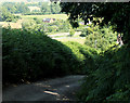
2010 : Byway to Knapp's Gate and Longhedge
Knapp's Gate is at the bottom of the hill.
The view further over is across Chatter Alley toward Sturford Lane.
Image: © Maurice Pullin
Taken: 28 Jun 2010
0.02 miles
2
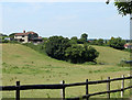
2010 : Fence and pasture near Longhedge
A continuation of the fence seen in Image]
The valley passes between Chapel Barton and Chatter Alley.
Image: © Maurice Pullin
Taken: 28 Jun 2010
0.08 miles
3
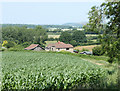
2010 : Field of maize near Knapp's Gate
Looking north east between Chapel Barton and Longhedge.
Image: © Maurice Pullin
Taken: 28 Jun 2010
0.08 miles
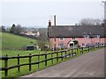
4
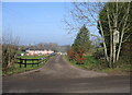
Longhedge Farm
A view looking north down the access road to Longhedge Farm.
Image: © Phil Williams
Taken: 5 Feb 2006
0.10 miles
5
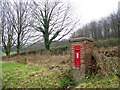
Edward VII postbox, Longhedge
The only postbox in the hamlet.
Image: © Maigheach-gheal
Taken: 30 Jan 2009
0.12 miles
6

Longhedge
Small hamlet on the edge of Longleat Estate.
Image: © Maigheach-gheal
Taken: 30 Jan 2009
0.14 miles
7
Longhedge Farm
One of the larger properties in the hamlet.
Image: © Maigheach-gheal
Taken: 30 Jan 2009
0.14 miles
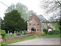
8
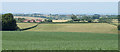
2010 : View west of north near Knapp's Gate
From a bridleway west of Longhedge.
Looking over a field of maize toward Corsley Heath and Chapmanslade.
Image: © Maurice Pullin
Taken: 28 Jun 2010
0.16 miles
10
Whitbourne Baptist Chapel, Chapel Barton, Corsley
Image: © Steve Roberts
Taken: 12 May 2016
0.23 miles