IMAGES TAKEN NEAR TO
Corsley, WARMINSTER, BA12 7PS
Introduction
This page details the photographs taken nearby to BA12 7PS by members of the Geograph project.
The Geograph project started in 2005 with the aim of publishing, organising and preserving representative images for every square kilometre of Great Britain, Ireland and the Isle of Man.

There are currently over 7.5m images from over14,400 individuals and you can help contribute to the project by visiting https://www.geograph.org.uk
Image Map
Images are licensed for reuse under creativecommons.org/licenses/by-sa/2.0
Notes
- Clicking on the map will re-center to the selected point.
- The higher the marker number, the further away the image location is from the centre of the postcode.
Image Listing (4 Images Found)
Images are licensed for reuse under creativecommons.org/licenses/by-sa/2.0
Image
Details
Distance
1

Park Farm
A view looking west over farmland towards Park Farm, with the public footpath from Deep Lane on the left.
Image: © Phil Williams
Taken: 7 May 2006
0.17 miles
2
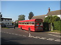
Heathway Southern End
The southern end of Heathway, at its junction with Lanes End Hill. A preserved Wilts & Dorset Bristol RE waits to leave for Warminster on a vintage bus running day.
Image: © David Roberts
Taken: 10 Oct 2010
0.18 miles
3
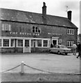
Royal Oak, Corsley Heath, Wiltshire taken 1968
The Royal Oak is still there today.
Image: © Christine Matthews
Taken: 14 Jul 1968
0.24 miles
4
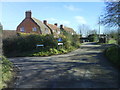
The Hollow and Heathway at Corsley Heath
This photo was taken from Heathway. The turning left is The Hollow which is the main road north of Corsley. Heathway becomes a cul-de-sac with footpaths at the end.
To the right of the photo are the gates to Corsley playing field.
Image: © Graham D
Taken: 8 Feb 2008
0.25 miles