IMAGES TAKEN NEAR TO
Mill Lane, WARMINSTER, BA12 7PQ
Introduction
This page details the photographs taken nearby to Mill Lane, BA12 7PQ by members of the Geograph project.
The Geograph project started in 2005 with the aim of publishing, organising and preserving representative images for every square kilometre of Great Britain, Ireland and the Isle of Man.

There are currently over 7.5m images from over14,400 individuals and you can help contribute to the project by visiting https://www.geograph.org.uk
Image Map
Images are licensed for reuse under creativecommons.org/licenses/by-sa/2.0
Notes
- Clicking on the map will re-center to the selected point.
- The higher the marker number, the further away the image location is from the centre of the postcode.
Image Listing (17 Images Found)
Images are licensed for reuse under creativecommons.org/licenses/by-sa/2.0
Image
Details
Distance
1

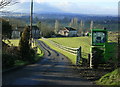
2009 : West from Lane End
The antidote to "Chocolate Box" pictures.
Taken from the A362 at the top of Lane End Hill.
Image: © Maurice Pullin
Taken: 13 Jan 2009
0.08 miles
2

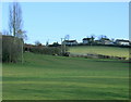
2009 : Pasture land off Mill Lane
Very few animals on the land at this time of year, most of the cattle will have been taken under shelter.
Image: © Maurice Pullin
Taken: 13 Jan 2009
0.11 miles
3
2009 : West from the A362 at Lane End
Near Corsley Heath. The A362 begins its descent into Frome here.
The limestone country of the eastern Mendips lies ahead with huge quarries at Whatley and Merehead among the hills to the left.
Image: © Maurice Pullin
Taken: 13 Jan 2009
0.12 miles
4
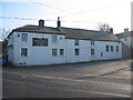
Lane End
A view looking southeast across the A362 to the White Hart public house at Lane End. The minor road joining the A362 from the right forms one of the access routes to Longleat Safari Park.
Image: © Phil Williams
Taken: 5 Feb 2006
0.13 miles
5

Neglected Phone Box
A view looking northwest on the minor road at Lane End to a neglected rural phone box. Although still shown on the OS map, it appears not to have been used or maintained for some time and is gradually disappearing into the undergrowth. Another casualty of mobile phones!
Image: © Phil Williams
Taken: 5 Feb 2006
0.14 miles
6

Edward VII postbox, Lane End
The postbox is fitted into the wall of the White Hart public house. It is also unusual to see a speed sign on a building wall.
Image: © Maigheach-gheal
Taken: 30 Jan 2009
0.15 miles
7
2009 : Pasture on Mill Lane
Looking west toward Lane End.
The strange effect in the trees is probably due to frost.
Image: © Maurice Pullin
Taken: 13 Jan 2009
0.15 miles
9
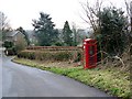
Telephone box, Lane End
K6 style telephone box on the narrow road through the hamlet.
Image: © Maigheach-gheal
Taken: 30 Jan 2009
0.17 miles
10

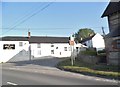
The White Hart, Corsley
A village pub by the A362.
Image: © Maigheach-gheal
Taken: 30 Jan 2009
0.17 miles