IMAGES TAKEN NEAR TO
Heath Close, WARMINSTER, BA12 7NX
Introduction
This page details the photographs taken nearby to Heath Close, BA12 7NX by members of the Geograph project.
The Geograph project started in 2005 with the aim of publishing, organising and preserving representative images for every square kilometre of Great Britain, Ireland and the Isle of Man.

There are currently over 7.5m images from over14,400 individuals and you can help contribute to the project by visiting https://www.geograph.org.uk
Image Map
Images are licensed for reuse under creativecommons.org/licenses/by-sa/2.0
Notes
- Clicking on the map will re-center to the selected point.
- The higher the marker number, the further away the image location is from the centre of the postcode.
Image Listing (11 Images Found)
Images are licensed for reuse under creativecommons.org/licenses/by-sa/2.0
Image
Details
Distance
1
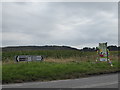
Junction on the A362 south-west of Corsley
Image: © Basher Eyre
Taken: 22 Aug 2016
0.03 miles
2
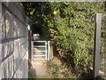
Footpath from Lanes End Hill to Heath close
A short footpath to the western side of Corsley Heath through a gate and along Heath close to Heathway. The footpath and Heath close isn't shown on the OS Explorer map.
Image: © Graham D
Taken: Unknown
0.03 miles
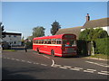
3
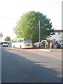
Lane's End Hill
Lane's End Hill, part of A362, looking west towards Frome at the junction with Heathway. A Bristol LH bus calls on Warminster vintage bus running day.
Image: © David Roberts
Taken: 10 Oct 2010
0.05 miles
4
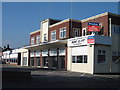
Art Deco former motor showrooms, Corsley Heath, nr. Warminster, Wiltshire
According to the estate agents, "Cavallino House is an Art Deco style building with significant motor racing history, previously accommodating a motor vehicle workshop and showroom". Cavallino Rampante is Italian for Prancing Horse and associated with Ferrari, so that may be the racing link. The building looks recently restore and maybe it previously had metal Crittall windows.
Image: © Alan Cooper
Taken: 10 Oct 2010
0.06 miles
5
Sign for the Royal Oak, Corsley Heath
The sign shows Charles II and Colonel Carless who hide in an oak tree to avoid detection by the Roundheads.
Image: © Maigheach-gheal
Taken: 16 Mar 2009
0.07 miles
6
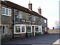
The Royal Oak, Corsley Heath
It is believed that the pub is haunted by a lady in black.
Image: © Maigheach-gheal
Taken: 16 Mar 2009
0.09 miles
7
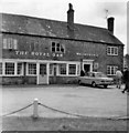
Royal Oak, Corsley Heath, Wiltshire taken 1968
The Royal Oak is still there today.
Image: © Christine Matthews
Taken: 14 Jul 1968
0.10 miles
8
Heathway Southern End
The southern end of Heathway, at its junction with Lanes End Hill. A preserved Wilts & Dorset Bristol RE waits to leave for Warminster on a vintage bus running day.
Image: © David Roberts
Taken: 10 Oct 2010
0.13 miles
9
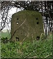
Old Milestone by the A362, Lanes End Hill, Corsley Parish
Stone post (plate lost) by the A362, in parish of CORSLEY (WEST WILTSHIRE District), by southbound lay-by 200m West of village in hedgerow, by the road, on North side of road. Frome iron plate, erected by the Frome turnpike trust in the 18th century.
Inscription once read:-
(Frome)
(3)
(Warminster)
(4)
Milestone Society National ID: WI_WMFR04.
Image: © M Faherty
Taken: 10 Mar 2007
0.14 miles
10
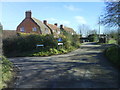
The Hollow and Heathway at Corsley Heath
This photo was taken from Heathway. The turning left is The Hollow which is the main road north of Corsley. Heathway becomes a cul-de-sac with footpaths at the end.
To the right of the photo are the gates to Corsley playing field.
Image: © Graham D
Taken: 8 Feb 2008
0.20 miles