
IMAGES TAKEN NEAR TO
Dertford, WARMINSTER, BA12 7NR
Introduction
This page details the photographs taken nearby to Dertford, BA12 7NR by members of the Geograph project.
The Geograph project started in 2005 with the aim of publishing, organising and preserving representative images for every square kilometre of Great Britain, Ireland and the Isle of Man.

There are currently over 7.5m images from over14,400 individuals and you can help contribute to the project by visiting https://www.geograph.org.uk
Image Map
Images are licensed for reuse under creativecommons.org/licenses/by-sa/2.0
Notes
- Clicking on the map will re-center to the selected point.
- The higher the marker number, the further away the image location is from the centre of the postcode.
Image Listing (5 Images Found)
Images are licensed for reuse under creativecommons.org/licenses/by-sa/2.0
Image
Details
Distance
1
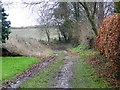
Bridleway, Lane End
The bridleway takes walkers and riders to the A362.
Image: © Maigheach-gheal
Taken: 30 Jan 2009
0.14 miles
2
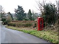
Telephone box, Lane End
K6 style telephone box on the narrow road through the hamlet.
Image: © Maigheach-gheal
Taken: 30 Jan 2009
0.15 miles
3
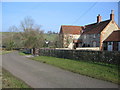
Wardens Farm
A view looking northeast to the farmhouse at Wardens Farm. The rooftops of the hamlet of Dertfords are visible in the distance.
Image: © Phil Williams
Taken: 5 Feb 2006
0.17 miles
4

Neglected Phone Box
A view looking northwest on the minor road at Lane End to a neglected rural phone box. Although still shown on the OS map, it appears not to have been used or maintained for some time and is gradually disappearing into the undergrowth. Another casualty of mobile phones!
Image: © Phil Williams
Taken: 5 Feb 2006
0.18 miles
5
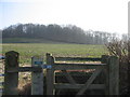
Dertfords Wood
A view looking southeast across farmland towards Dertfords Wood, from the start of the public footpath.
Image: © Phil Williams
Taken: 5 Feb 2006
0.24 miles