IMAGES TAKEN NEAR TO
Corsley, WARMINSTER, BA12 7NF
Introduction
This page details the photographs taken nearby to BA12 7NF by members of the Geograph project.
The Geograph project started in 2005 with the aim of publishing, organising and preserving representative images for every square kilometre of Great Britain, Ireland and the Isle of Man.

There are currently over 7.5m images from over14,400 individuals and you can help contribute to the project by visiting https://www.geograph.org.uk
Image Map
Images are licensed for reuse under creativecommons.org/licenses/by-sa/2.0
Notes
- Clicking on the map will re-center to the selected point.
- The higher the marker number, the further away the image location is from the centre of the postcode.
Image Listing (4 Images Found)
Images are licensed for reuse under creativecommons.org/licenses/by-sa/2.0
Image
Details
Distance
1
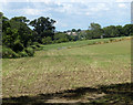
2010 : Norton Common
One time common land which has long been fenced off and taken into private ownership.
Image: © Maurice Pullin
Taken: 2 Aug 2010
0.12 miles
2
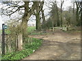
Bridleway north of Longleat
This public bridleway runs along the northern fringe of Longleat park, from the western entrance of the Safari park through Dertford's wood to the eastern entrance at Longhedge.
Image: © Graham D
Taken: 9 Apr 2008
0.13 miles
3
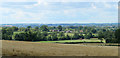
2010 : A field of stubble, Norton Common
Looking north west, the stubble was most likely wheat.
The view is toward East Woodlands with Frome in the distance to the right.
Image: © Maurice Pullin
Taken: 2 Aug 2010
0.17 miles
4
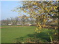
Early catkins
A view looking northeast towards the hamlet of Dertfords with some early catkins in the hedgerow catching the late afternoon sunshine.
Image: © Phil Williams
Taken: 5 Feb 2006
0.18 miles