IMAGES TAKEN NEAR TO
Horningsham, WARMINSTER, BA12 7NA
Introduction
This page details the photographs taken nearby to BA12 7NA by members of the Geograph project.
The Geograph project started in 2005 with the aim of publishing, organising and preserving representative images for every square kilometre of Great Britain, Ireland and the Isle of Man.

There are currently over 7.5m images from over14,400 individuals and you can help contribute to the project by visiting https://www.geograph.org.uk
Image Map
Images are licensed for reuse under creativecommons.org/licenses/by-sa/2.0
Notes
- Clicking on the map will re-center to the selected point.
- The higher the marker number, the further away the image location is from the centre of the postcode.
Image Listing (2 Images Found)
Images are licensed for reuse under creativecommons.org/licenses/by-sa/2.0
Image
Details
Distance
1
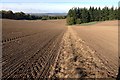
Farmland near Horningsham
Recently ploughed and harrowed field with woodland margins.
Image: © James Harrison
Taken: 20 Oct 2015
0.21 miles
2
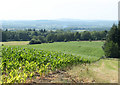
2010 : Field of maize north of Forest Road
Looking north west.
The maize has just started to grow, in a few weeks time this view will be impossible.
Beyond the woods we are looking into the Frome valley.
Image: © Maurice Pullin
Taken: 28 Jun 2010
0.24 miles