IMAGES TAKEN NEAR TO
Water Lane, WARMINSTER, BA12 7LL
Introduction
This page details the photographs taken nearby to Water Lane, BA12 7LL by members of the Geograph project.
The Geograph project started in 2005 with the aim of publishing, organising and preserving representative images for every square kilometre of Great Britain, Ireland and the Isle of Man.

There are currently over 7.5m images from over14,400 individuals and you can help contribute to the project by visiting https://www.geograph.org.uk
Image Map
Images are licensed for reuse under creativecommons.org/licenses/by-sa/2.0
Notes
- Clicking on the map will re-center to the selected point.
- The higher the marker number, the further away the image location is from the centre of the postcode.
Image Listing (10 Images Found)
Images are licensed for reuse under creativecommons.org/licenses/by-sa/2.0
Image
Details
Distance
1
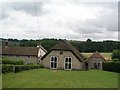
Horningsham chapel
one of the earliest non-conformist chapels - 1566
Image: © mym
Taken: 21 Jul 2003
0.07 miles
2
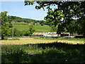
2009 : Outbuildings at Mill Farm
White Street in the distance.
Image: © Maurice Pullin
Taken: 2 Jun 2009
0.09 miles
3
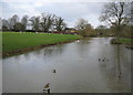
Mill Pond and Mill farm, Horningsham
Picturesqie mill pond in Horningsham on a frosty bright November morning.
Image: © Philip Halling
Taken: 17 Nov 2017
0.13 miles
4

Road entering Horningsham
Country road entering the village of Horningsham.
Image: © Philip Halling
Taken: 17 Nov 2017
0.14 miles
5
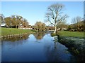
The Mill Pond, Horningsham
A view looking north from the wooden footbridge over the Mill Pond at Horningsham.
Image: © Phil Williams
Taken: 25 Feb 2007
0.14 miles
6
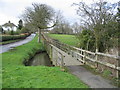
Watery Lane. Horningsham
A view looking west along Watery lane showing the wooden footbridge over the millpond at Horningsham.
Image: © Phil Williams
Taken: 25 Feb 2007
0.14 miles
7

Roadside footbridge
A roadside footbridge, on a frosty November morning, crossing the southern of Mill Pond in Horningsham.
Image: © Philip Halling
Taken: 17 Nov 2017
0.15 miles
8
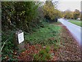
Horningsham, milestone
On the road from Maiden Bradley; one of five erected to show the distance to Longleat House; C18.
Image: © Mike Faherty
Taken: 4 Nov 2011
0.23 miles
9
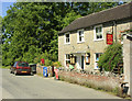
2009 : Pottle Street Post Office, Horningsham
Post Office and Stores. The proprietors were taking the sun in the front garden.
Image: © Maurice Pullin
Taken: 2 Jun 2009
0.23 miles
10
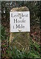
Old Milestone by Lodge Road, Horningsham
Metal plate attached to stone post by the UC road, in parish of HORNINGSHAM (WEST WILTSHIRE District), Lodge Road; 150m South of Bath Arms, 50m South of bus shelter, by the road, on West side of road. Longleat iron plate erected by a private estate in the 18th century.
Inscription reads:-
Longleat
Houſe
1 Mile
Grade II listed.
List Entry Number: 1364360 https://historicengland.org.uk/listing/the-list/list-entry/1364360
Milestone Society National ID: WI_LL01S
Image: © M Faherty
Taken: 6 Mar 2007
0.24 miles