IMAGES TAKEN NEAR TO
Horningsham, WARMINSTER, BA12 7JP
Introduction
This page details the photographs taken nearby to BA12 7JP by members of the Geograph project.
The Geograph project started in 2005 with the aim of publishing, organising and preserving representative images for every square kilometre of Great Britain, Ireland and the Isle of Man.

There are currently over 7.5m images from over14,400 individuals and you can help contribute to the project by visiting https://www.geograph.org.uk
Image Map
Images are licensed for reuse under creativecommons.org/licenses/by-sa/2.0
Notes
- Clicking on the map will re-center to the selected point.
- The higher the marker number, the further away the image location is from the centre of the postcode.
Image Listing (8 Images Found)
Images are licensed for reuse under creativecommons.org/licenses/by-sa/2.0
Image
Details
Distance
1
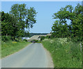
2009 : Lane to Round Hill Farm
Then on to Horningsham.
Image: © Maurice Pullin
Taken: 2 Jun 2009
0.03 miles
2
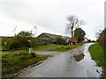
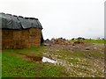
Horningsham, clamp & barn
At Round Hill Farm.
Image: © Mike Faherty
Taken: 4 Nov 2011
0.07 miles
3
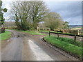
Public Footpath near Round Hill Farm
A view looking to the north towards the start of the public footpath to Horningsham from Round Hill Farm.
Image: © Phil Williams
Taken: 25 Feb 2007
0.09 miles
4

2009 : Maize at the beginning of June
Near Round Hill Farm.
Image: © Maurice Pullin
Taken: 2 Jun 2009
0.15 miles
5
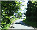
2009 : Looking north near Round Hill Farm
Image: © Maurice Pullin
Taken: 2 Jun 2009
0.16 miles
6
Horningsham, haystack
Near Round Hill Farm; dairy cattle in the background.
Image: © Mike Faherty
Taken: 4 Nov 2011
0.17 miles
7

Horningsham, autumn colours
Provided by beech trees, on the road to Maiden Bradley.
Image: © Mike Faherty
Taken: 4 Nov 2011
0.19 miles
8

Milestone near Round Hill Farm
A view looking to the northeast across the lane to Horningsham showing a milestone indicating "Longleat House 2 Miles".
Image: © Phil Williams
Taken: 25 Feb 2007
0.25 miles