IMAGES TAKEN NEAR TO
The Rank, WARMINSTER, BA12 7JF
Introduction
This page details the photographs taken nearby to The Rank, BA12 7JF by members of the Geograph project.
The Geograph project started in 2005 with the aim of publishing, organising and preserving representative images for every square kilometre of Great Britain, Ireland and the Isle of Man.

There are currently over 7.5m images from over14,400 individuals and you can help contribute to the project by visiting https://www.geograph.org.uk
Image Map
Images are licensed for reuse under creativecommons.org/licenses/by-sa/2.0
Notes
- Clicking on the map will re-center to the selected point.
- The higher the marker number, the further away the image location is from the centre of the postcode.
Image Listing (47 Images Found)
Images are licensed for reuse under creativecommons.org/licenses/by-sa/2.0
Image
Details
Distance
1
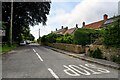
Maiden Bradley with Yarnfield : The Rank
Looking along The Rank off Church Street.
Image: © Lewis Clarke
Taken: 28 Jul 2023
0.02 miles
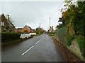
2
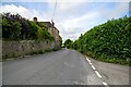
Maiden Bradley with Yarnfield : Frome Road B3092
Looking along the B3092.
Image: © Lewis Clarke
Taken: 28 Jul 2023
0.03 miles
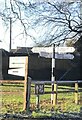
4
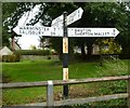
Old Direction Sign - Signpost by the B3092, Maiden Bradley
Cap finial - 4 arms; Royal Label Factory by the B3092, in parish of Maiden Bradley with Yarnfield (Salisbury District), Maiden Bradley, village crossroads in field. Church Street junction with Bradley Lane
Surveyed
Milestone Society National ID: WI_ST8039
Image: © Milestone Society
Taken: Unknown
0.03 miles
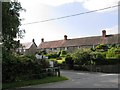
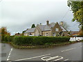
5
Maiden Bradley High Street
Seen from the village crossroads. Apart from the village hall (middle distance, left), most village facilities seem now to be in Church Street.
Image: © Mike Faherty
Taken: 4 Nov 2011
0.03 miles
7
Maiden Bradley, former school
At the corner of Church and High Streets; now residential.
Image: © Mike Faherty
Taken: 4 Nov 2011
0.04 miles
8
Maiden Bradley, drinking fountain
On Church Street; according to the inscription, erected in 1891 by the Duke of Somerset, for the refreshment of travellers and their horses; now used as flower planter.
Image: © Mike Faherty
Taken: 4 Nov 2011
0.04 miles
9
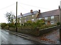
Maiden Newton, cottages
On The Rank; a recent newspaper article suggested these cottages were once used by silk-spinners; the furthest cottage is "Old White Hart Cottage", presumably once a village pub. http://www.guardian.co.uk/environment/2011/oct/31/country-diary-maiden-bradley-wiltshire?INTCMP=SRCH
Image: © Mike Faherty
Taken: 4 Nov 2011
0.04 miles
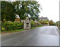
10
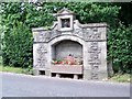
Maiden Bradley Fountain
A drinking trough for horses, presented to Maiden Bradley by Algernon, 14th Duke of Somerset, in 1891.
Image: © Maigheach-gheal
Taken: 5 Jul 2009
0.04 miles