IMAGES TAKEN NEAR TO
Maiden Bradley, WARMINSTER, BA12 7HY
Introduction
This page details the photographs taken nearby to BA12 7HY by members of the Geograph project.
The Geograph project started in 2005 with the aim of publishing, organising and preserving representative images for every square kilometre of Great Britain, Ireland and the Isle of Man.

There are currently over 7.5m images from over14,400 individuals and you can help contribute to the project by visiting https://www.geograph.org.uk
Image Map
Images are licensed for reuse under creativecommons.org/licenses/by-sa/2.0
Notes
- Clicking on the map will re-center to the selected point.
- The higher the marker number, the further away the image location is from the centre of the postcode.
Image Listing (7 Images Found)
Images are licensed for reuse under creativecommons.org/licenses/by-sa/2.0
Image
Details
Distance
1
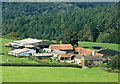
2008 : Manor Farm from Long Knoll
Using the trigpoint on Long Knoll as a camera support.
Image: © Maurice Pullin
Taken: 22 Aug 2008
0.01 miles
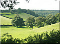
2
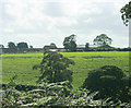
2009 : Across the valley to Manor Farm
The field on the other side of the valley bears traces of an ancient village.
Image: © Maurice Pullin
Taken: 4 Sep 2009
0.03 miles
3
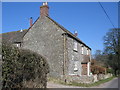
Manor Farm
A view looking northeast to the farmhouse at Manor Farm.
Image: © Phil Williams
Taken: 19 Mar 2006
0.04 miles
4
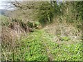
Footpath near Maiden Bradley
The footpath takes walkers from Manor Farm towards Moulton's Park Wood.
Image: © Maigheach-gheal
Taken: 19 Mar 2011
0.12 miles
5

2009 : Pasture near Manor Farm
The main item of interest here is the field on the other side of the valley which contains all that is left of an ancient village. Just a few humps and bumps.
Image: © Maurice Pullin
Taken: 4 Sep 2009
0.12 miles
6
2009 : Small valley off Bradley Lane
OS Explorer 142 does not give this valley a name, may be too small to have one.
Image: © Maurice Pullin
Taken: 4 Sep 2009
0.17 miles
7
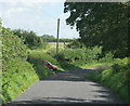
2009 : Bradley Lane near Manor Farm
In this direction Bradley Lane goes practically nowhere, and very pleasant it is.
Image: © Maurice Pullin
Taken: 4 Sep 2009
0.22 miles