IMAGES TAKEN NEAR TO
Rodmead, WARMINSTER, BA12 7HP
Introduction
This page details the photographs taken nearby to Rodmead, BA12 7HP by members of the Geograph project.
The Geograph project started in 2005 with the aim of publishing, organising and preserving representative images for every square kilometre of Great Britain, Ireland and the Isle of Man.

There are currently over 7.5m images from over14,400 individuals and you can help contribute to the project by visiting https://www.geograph.org.uk
Image Map
Images are licensed for reuse under creativecommons.org/licenses/by-sa/2.0
Notes
- Clicking on the map will re-center to the selected point.
- The higher the marker number, the further away the image location is from the centre of the postcode.
Image Listing (4 Images Found)
Images are licensed for reuse under creativecommons.org/licenses/by-sa/2.0
Image
Details
Distance
1
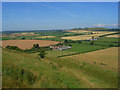
Farmland, Maiden Bradley
A view over Rodmead Farm from the flank of Rodmead Hill with Long Knoll in the background to the right.
Image: © Andrew Smith
Taken: 27 Jul 2008
0.06 miles
2

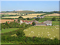
Rodmead Farm
Extensive farm buildings viewed from the scarp to their south. Long Knoll is in the background.
Image: © Andrew Smith
Taken: 23 Aug 2007
0.09 miles
3
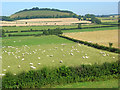
Rodmead Farm
Mixed livestock and arable production. Long Knoll is in the background.
Image: © Andrew Smith
Taken: 27 Jul 2008
0.09 miles
4
Farmland, Maiden Bradley
Pastures at Rodmead Farm with a view over arable fields to Little Knoll.
Image: © Andrew Smith
Taken: 27 Jul 2008
0.10 miles