IMAGES TAKEN NEAR TO
Maiden Bradley, WARMINSTER, BA12 7HJ
Introduction
This page details the photographs taken nearby to BA12 7HJ by members of the Geograph project.
The Geograph project started in 2005 with the aim of publishing, organising and preserving representative images for every square kilometre of Great Britain, Ireland and the Isle of Man.

There are currently over 7.5m images from over14,400 individuals and you can help contribute to the project by visiting https://www.geograph.org.uk
Image Map
Images are licensed for reuse under creativecommons.org/licenses/by-sa/2.0
Notes
- Clicking on the map will re-center to the selected point.
- The higher the marker number, the further away the image location is from the centre of the postcode.
Image Listing (11 Images Found)
Images are licensed for reuse under creativecommons.org/licenses/by-sa/2.0
Image
Details
Distance
1
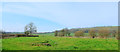
2012 : North west from the road from Kingston Deverill
To Maiden Bradley.
Brimsdown Hill is to the right.
Image: © Maurice Pullin
Taken: 23 Mar 2012
0.12 miles
2
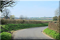
2012 : Heading west to Maiden Bradley
Image: © Maurice Pullin
Taken: 23 Mar 2012
0.13 miles
3
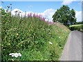
Rosebay Willow-herb near Maiden Bradley
Named after its long, narrow, willow like leaves, the willow-herb grows as an upright spike covered with pink flowers.
Rosebay willow-herb, or fireweed, was a rare native species which suddenly began to spread in about 1860, perhaps as a result of genetic change; it is now everywhere, except the far west of Ireland, and is abundant on waste land round towns, in cleared woodland and road side verges.
Image: © Maigheach-gheal
Taken: 5 Jul 2009
0.14 miles
4
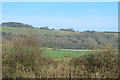
2012 : East along the bottom of Brimsdown Hill
Not to be confused with Brims Down which is about two miles to the east.
Marcombe Wood is at the foot of the hill.
Image: © Maurice Pullin
Taken: 23 Mar 2012
0.16 miles
5
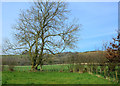
2012 : An oak tree of many winters
A good few summers as well, from the base of the trunk one would think well over 600. Seems to have been coppiced at some time early in its life giving it extra years.
Holcombe Hole is in the hill behind with Bidcombe Down at the top.
Image: © Maurice Pullin
Taken: 23 Mar 2012
0.18 miles
6
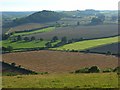
Farmland, Maiden Bradley
Looking down from Holcombe Hole. Fields backed by Little Knoll and Long Knoll.
Image: © Andrew Smith
Taken: 25 Aug 2007
0.18 miles
7
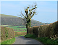
2012 : An old oak tree, nicely pruned
As well as improving safety for passers by on the road this treatment helps preserve the life of the tree. Already 300 to 400 years old, given the absence of lightning strikes, road widening, etc. it could last another 400 or 500 years.
Brimsdown Hill is in the background, the road continues to Kingston Deverill.
Image: © Maurice Pullin
Taken: 23 Mar 2012
0.19 miles
8
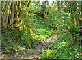
2012 : A winterbourne or winterborne
A winterborne or winterbourne is a stream or river that is dry during the summer months, here is an excellent example, though this year it is dry in the middle of March.
Image: © Maurice Pullin
Taken: 23 Mar 2012
0.19 miles
9
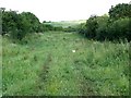
Bridleway near Maiden Bradley
The bridleway takes walkers and riders to Brimsdown Hill. The wide drove like path is at present being grazed by cattle.
Image: © Maigheach-gheal
Taken: 5 Jul 2009
0.25 miles
10
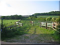
Bridleway to Brimsdown Hill
A view looking north to the start of the bridleway to Brimsdown Hill, visible on the right of the image.
Image: © Phil Williams
Taken: 1 Jun 2007
0.25 miles