IMAGES TAKEN NEAR TO
Kingston Deverill, WARMINSTER, BA12 7HD
Introduction
This page details the photographs taken nearby to BA12 7HD by members of the Geograph project.
The Geograph project started in 2005 with the aim of publishing, organising and preserving representative images for every square kilometre of Great Britain, Ireland and the Isle of Man.

There are currently over 7.5m images from over14,400 individuals and you can help contribute to the project by visiting https://www.geograph.org.uk
Image Map
Images are licensed for reuse under creativecommons.org/licenses/by-sa/2.0
Notes
- Clicking on the map will re-center to the selected point.
- The higher the marker number, the further away the image location is from the centre of the postcode.
Image Listing (24 Images Found)
Images are licensed for reuse under creativecommons.org/licenses/by-sa/2.0
Image
Details
Distance
1
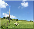
2012 : Whitepits, near Kingston Deverill
Whitepits is a hamlet north of Kingston Deverill on the Maiden Bradley road.
Image: © Maurice Pullin
Taken: 23 Mar 2012
0.04 miles
2
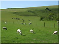
White sheep at Whitepits
Maybe all that chalk in the soil is keeping the livestock white.
Image: © Neil Owen
Taken: 17 Jul 2020
0.07 miles
3
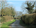
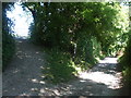
2012 : The Kingston Deverill bypass
A quiet lane north east of the village starting near Whitepits and ending on the B3095.
Image: © Maurice Pullin
Taken: 23 Mar 2012
0.14 miles
4
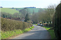
2012 : Down the hill to Kingston Deverill
Leaving Whitepits and entering Kingston Deverill from the north.
King's Hill is on the other side of the River Wylye which is also known as the Deverill above Longbridge Deverill, giving its name to villages at this end of the valley.
Image: © Maurice Pullin
Taken: 23 Mar 2012
0.14 miles
5
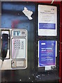
We're thinking of removing this equipment
Notices of impending doom in this phone box. See http://www.geograph.org.uk/photo/6544757 for a wider view.
Image: © Neil Owen
Taken: 17 Jul 2020
0.15 miles
6
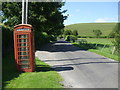
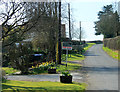
Get it whilst you still can
A telephone box in a quiet village - a diminishing sight. What is more diminished is a telephone box with a telephone in it. This one does! However, there are notices inside that hang like an axe above it. See http://www.geograph.org.uk/photo/6544761 for a look at the impending doom for this equipment.
Image: © Neil Owen
Taken: 17 Jul 2020
0.15 miles
7
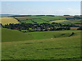
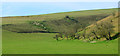
The valley down to Whitepits
The chalk-land downs of Wiltshire often feature such pronounced geography.
Image: © Neil Owen
Taken: 17 Jul 2020
0.17 miles
8
2012 : The combe with no name, Kingston Deverill
Turning our backs on the village we look into a mysterious hollow, a dry valley, bottom, or combe which I shall call Whitepits Combe, because that is the place at the bottom end, also, Whitepits Down is at the top of the hill beyond. Cold Kitchen Hill is beyond that.
OS Explorer Map 143 tells us there are ancient earthworks on the hills either side. Markings are just visible on the hill to the left.
Image: © Maurice Pullin
Taken: 23 Mar 2012
0.18 miles
9
The Mid Wilts Way restarts here
A minor road to Whitepits momentarily halts the long distance path. Turn left for the uphill trek to Cold Kitchen Hill.
Image: © Neil Owen
Taken: 17 Jul 2020
0.19 miles