IMAGES TAKEN NEAR TO
Monkton Deverill, WARMINSTER, BA12 7EU
Introduction
This page details the photographs taken nearby to BA12 7EU by members of the Geograph project.
The Geograph project started in 2005 with the aim of publishing, organising and preserving representative images for every square kilometre of Great Britain, Ireland and the Isle of Man.

There are currently over 7.5m images from over14,400 individuals and you can help contribute to the project by visiting https://www.geograph.org.uk
Image Map
Images are licensed for reuse under creativecommons.org/licenses/by-sa/2.0
Notes
- Clicking on the map will re-center to the selected point.
- The higher the marker number, the further away the image location is from the centre of the postcode.
Image Listing (21 Images Found)
Images are licensed for reuse under creativecommons.org/licenses/by-sa/2.0
Image
Details
Distance
2
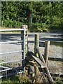
A very narrow stile
Getting over this one requires a great exhalation. The extra fence wire is merely complimentary.
Image: © Neil Owen
Taken: 17 Jul 2020
0.06 miles
3
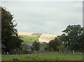
2009 : Manor Farm, Monkton Deverill
Seen from the other side of Monkton Deverill.
Boar's Bottom is on the other side of the farm, below the fields that have been recently cropped.
Image: © Maurice Pullin
Taken: 29 Sep 2009
0.09 miles
4
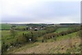
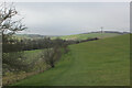
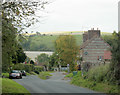
Monkton Deverill from Mill Down
In the valley of the River Wylye
Image: © Tim Heaton
Taken: 1 Feb 2022
0.12 miles
6
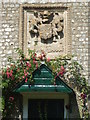
A stone coat
The carved stonework appear to show a coat of arms. The village has had a number of links to royalty and lords of the manor in centuries past, so perhaps this relates to one of them. See Image] for a wider view.
Image: © Neil Owen
Taken: 17 Jul 2020
0.13 miles
7
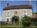
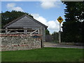
A house with a coat
See Image] for a closer look at the coat of arms on this modest home in Monkton Deverill.
Image: © Neil Owen
Taken: 17 Jul 2020
0.13 miles
8
Footpath on Mill Down
A faint path can be traced in the grass beside the fence as it crosses chalk downland towards Kingston Deverill
Image: © Chris Heaton
Taken: 1 Feb 2022
0.14 miles
9
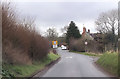
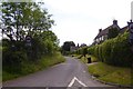
2009 : Entering Monkton Deverill from the south east
The 30mph limit sign appears to be telling the houseowner he has a speed limit on his own driveway.
Image: © Maurice Pullin
Taken: 29 Sep 2009
0.17 miles
10
Lookout for Skippy!
An unexpected sign in Monkton Deverill. Perhaps kangaroos are the new alpacas?
Image: © Neil Owen
Taken: 17 Jul 2020
0.17 miles