IMAGES TAKEN NEAR TO
King Alfreds Close, WARMINSTER, BA12 7ES
Introduction
This page details the photographs taken nearby to King Alfreds Close, BA12 7ES by members of the Geograph project.
The Geograph project started in 2005 with the aim of publishing, organising and preserving representative images for every square kilometre of Great Britain, Ireland and the Isle of Man.

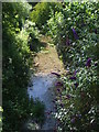
There are currently over 7.5m images from over14,400 individuals and you can help contribute to the project by visiting https://www.geograph.org.uk
Image Map
Images are licensed for reuse under creativecommons.org/licenses/by-sa/2.0
Notes
- Clicking on the map will re-center to the selected point.
- The higher the marker number, the further away the image location is from the centre of the postcode.
Image Listing (75 Images Found)
Images are licensed for reuse under creativecommons.org/licenses/by-sa/2.0
Image
Details
Distance
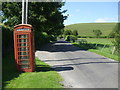
1

We're thinking of removing this equipment
Notices of impending doom in this phone box. See http://www.geograph.org.uk/photo/6544757 for a wider view.
Image: © Neil Owen
Taken: 17 Jul 2020
0.02 miles
2
Get it whilst you still can
A telephone box in a quiet village - a diminishing sight. What is more diminished is a telephone box with a telephone in it. This one does! However, there are notices inside that hang like an axe above it. See http://www.geograph.org.uk/photo/6544761 for a look at the impending doom for this equipment.
Image: © Neil Owen
Taken: 17 Jul 2020
0.02 miles
3
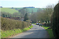
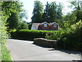
2012 : Down the hill to Kingston Deverill
Leaving Whitepits and entering Kingston Deverill from the north.
King's Hill is on the other side of the River Wylye which is also known as the Deverill above Longbridge Deverill, giving its name to villages at this end of the valley.
Image: © Maurice Pullin
Taken: 23 Mar 2012
0.03 miles
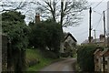
4
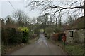
Heading towards the B3095 in Kingston Deverill
Quiet lane in the village of Kingston Deverill adopted by the Mid Wilts Way long distance footpath
Image: © Chris Heaton
Taken: 1 Feb 2022
0.06 miles
5
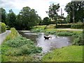
River Wylye at Kingston Deverill
The river widens out at this point and it forms a pond like area in the village.
Image: © Maigheach-gheal
Taken: 20 Jul 2008
0.06 miles
6
The Wylye in Kingston Deverill
A cool and clear river, the Wylye.
Image: © Neil Owen
Taken: 17 Jul 2020
0.07 miles
7
Crossing the River Wylye
A bridge in Kingston Deverill, spanning the Wylye, and close to the old school. See Image] for a nineteenth century benchmark on it.
Image: © Neil Owen
Taken: 17 Jul 2020
0.07 miles
8
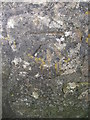
Benchmark on the bridge over the Wylye
A cutmark, as listed in the Benchmark Database: https://www.bench-marks.org.uk/bm55948 , on the little stone bridge in Kingston Deverill. See Image] for a wider view.
Image: © Neil Owen
Taken: 17 Jul 2020
0.07 miles
9
Kingston Deverill
Small ancient village in the Wylye Valley
Image: © Chris Heaton
Taken: 1 Feb 2022
0.10 miles
10
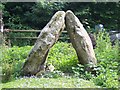
Egbert's Stone
Egbert's Stone is where King Alfred The Great changed the course of British history and firmly contributed to the establishment of Christendom here in fair Albion. It's a fantastic tale of courage and clarity of mind under extreme duress. But, are these the stones which once comprised the original structure, now resting here in a rough paddock at Kingston Deverill, next to the Norman Church of St. Mary the Virgin, that once marked the meeting place, up on nearby Court Hill, where Alfred pulled his fierce retaliatory Saxon militia together against the occupying Danes, who had betrayed a Christmastide ceasefire at Chippenham (imagine that), thereby causing the king to flee? I'd like to think so, although the likelihood is that the actual moot was near Alfred's Tower a few miles away at a convenient intersection of marching routes. The story is complex and so I thought to blog a synopsis:
http://bit.ly/EgbertsStone
Image: © John Potts
Taken: 4 Jul 2011
0.11 miles