IMAGES TAKEN NEAR TO
Brixton Deverill, WARMINSTER, BA12 7EN
Introduction
This page details the photographs taken nearby to BA12 7EN by members of the Geograph project.
The Geograph project started in 2005 with the aim of publishing, organising and preserving representative images for every square kilometre of Great Britain, Ireland and the Isle of Man.

There are currently over 7.5m images from over14,400 individuals and you can help contribute to the project by visiting https://www.geograph.org.uk
Image Map
Images are licensed for reuse under creativecommons.org/licenses/by-sa/2.0
Notes
- Clicking on the map will re-center to the selected point.
- The higher the marker number, the further away the image location is from the centre of the postcode.
Image Listing (13 Images Found)
Images are licensed for reuse under creativecommons.org/licenses/by-sa/2.0
Image
Details
Distance
1
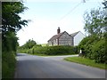
House with brick and stone wall, Brixton Deverill
Image: © David Smith
Taken: 1 Jun 2017
0.01 miles
2
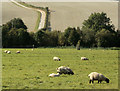
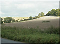
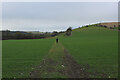
2009 : Sheep meadow south of Brixton Deverill
Seen from the B3095.
Whitecliff Farm is seen on the left through the trees. Boar's Bottom behind it rises to Cold Kitchen Hill.
Image: © Maurice Pullin
Taken: 29 Sep 2009
0.07 miles
3
2009 : Sheep safely grazing near Brixton Deverill
Seen from the B3095
The River Wylye flows through the trees opposite on its way north to Warminster.
On the other side of the valley a farm track heads up, eventually, to Cold Kitchen Hill.
Image: © Maurice Pullin
Taken: 29 Sep 2009
0.09 miles
4
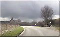
Whitecliff Farm
Farming operation near Brixton Deverill
Image: © Chris Heaton
Taken: 1 Feb 2022
0.11 miles
5
2009 : Recently cropped fields south of Brixton Deverill
Seen from the B3095 near Laurel Cottage.
Image: © Maurice Pullin
Taken: 29 Sep 2009
0.11 miles
6
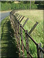
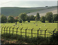
Fencing on the B3095
Some traditional style of iron fencing along the bend. Little clumps of wool lined its lower reaches.
Image: © Neil Owen
Taken: 17 Jul 2020
0.15 miles
7
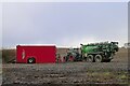
Refilling a Joskin slurry tanker
The tanker is fitted with tine injectors. Injection of manure slurry, rather than surface spreading, increases nutrient availability to the soil, and greatly reduces pollution of the atmosphere (ammonia is a major component of harmful particulates) and risk of runoff into nearby streams.
Image: © Tim Heaton
Taken: 1 Feb 2022
0.17 miles
10
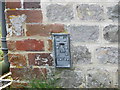
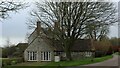
Ordnance Survey Flush Bracket G3790
This can be found on the wall of Laurel House - a private dwelling.
For more detail see : http://www.bench-marks.org.uk/bm15913
Image: © Peter Wood
Taken: 13 Feb 2017
0.19 miles