IMAGES TAKEN NEAR TO
Brixton Deverill, WARMINSTER, BA12 7EJ
Introduction
This page details the photographs taken nearby to BA12 7EJ by members of the Geograph project.
The Geograph project started in 2005 with the aim of publishing, organising and preserving representative images for every square kilometre of Great Britain, Ireland and the Isle of Man.

There are currently over 7.5m images from over14,400 individuals and you can help contribute to the project by visiting https://www.geograph.org.uk
Image Map
Images are licensed for reuse under creativecommons.org/licenses/by-sa/2.0
Notes
- Clicking on the map will re-center to the selected point.
- The higher the marker number, the further away the image location is from the centre of the postcode.
Image Listing (68 Images Found)
Images are licensed for reuse under creativecommons.org/licenses/by-sa/2.0
Image
Details
Distance
4
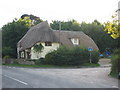
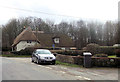
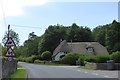
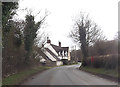
Thatched cottage at Brixton Deverill
This thatched cottage is on the B3095 at Brixton Deverill, just by the bridge over the River Wylye.
Image: © Phil Williams
Taken: 16 Sep 2005
0.03 miles
5
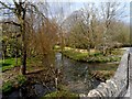
Bridge over River Wylye, Brixton Deverill
Image: © David Smith
Taken: 1 Jun 2017
0.05 miles
6
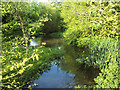
A river plate
The Wylye south of Brixton Deverill.
Image: © Neil Owen
Taken: 17 Jul 2020
0.05 miles
9
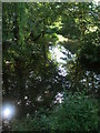
The Wylye at Brixton Deverill
The shady canopy belies the river's crisp and clear waters.
Image: © Neil Owen
Taken: 17 Jul 2020
0.06 miles
10
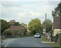
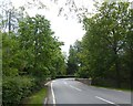
2009 : B3095 passing through Brixton Deverill
"The name Deverill refers to the River Deverill which flows through the whole valley. It rises to the west of Kingston and flows north, passing through the six villages. At Crockerton it meets the Shearwater stream and becomes the River Wylye. The name Deverill literally means ‘diving rill’. There are points along its route where it peters out and flows underground, hence the disappearing rill or stream.
The name Brixton refers to an 11th century landholder named Brictric. By 1435 the name had changed to Brightson, leading to the opinion that this was the site of Ecbrighte’s stan or Egbert’s stone. This is the site where King Alfred is said to have gathered his men before Ethandune, although the actual site may well have been at Penselwood, on the Somerset-Wiltshire-Dorset border. King Alfred has long been associated with the Deverill valley in legend and folklore, an example being the dedication of Monkton church. The story of Alfred and the cakes is supposed to have taken place in a field south of the rectory in Brixton, and tradition says that Alfred prayed for victory in the church on the eve of the Battle of Ethandune."
The above was copied from: http://www.wiltshire.gov.uk/community/getcom.php?id=32 where there is more of historical interest.
Image: © Maurice Pullin
Taken: 29 Sep 2009
0.06 miles