IMAGES TAKEN NEAR TO
The Marsh, WARMINSTER, BA12 7EA
Introduction
This page details the photographs taken nearby to The Marsh, BA12 7EA by members of the Geograph project.
The Geograph project started in 2005 with the aim of publishing, organising and preserving representative images for every square kilometre of Great Britain, Ireland and the Isle of Man.

There are currently over 7.5m images from over14,400 individuals and you can help contribute to the project by visiting https://www.geograph.org.uk
Image Map
Images are licensed for reuse under creativecommons.org/licenses/by-sa/2.0
Notes
- Clicking on the map will re-center to the selected point.
- The higher the marker number, the further away the image location is from the centre of the postcode.
Image Listing (30 Images Found)
Images are licensed for reuse under creativecommons.org/licenses/by-sa/2.0
Image
Details
Distance
1
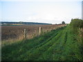
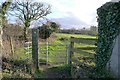
Bridleway to Long Ivor Farm
A view looking northeast along the bridleway to Long Ivor Farm.
Image: © Phil Williams
Taken: 13 Oct 2006
0.08 miles
2
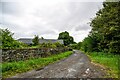
Footpath heading South from Sand Street, Longbridge Deverill
The footpath runs to the left of the boundary hedge - although it is marked as running on the right according to the map
Image: © Chris Heaton
Taken: 31 Jan 2022
0.15 miles
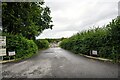
3
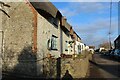
Longbridge Deverill : Road
A road off the A350.
Image: © Lewis Clarke
Taken: 31 Jul 2023
0.15 miles
4
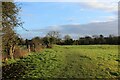
Footpath leaving Longbridge Deverill
Leading south towards Hill Deverill
Image: © Tim Heaton
Taken: 31 Jan 2022
0.15 miles
5
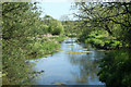
2010 : River Wylye at Longbridge Deverill
Looking upstream from the bridge on Sand Street.
Image: © Maurice Pullin
Taken: 22 May 2010
0.15 miles
6
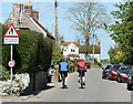
2010 : Cyclists in Longbridge Deverill
Heading east on the road to Sutton Veny.
"The village of Longbridge Deverill is part of the Deverill valley. This encompasses six villages on the Wiltshire Downs where the western edge of Salisbury Plain dips into Somerset. Longbridge is the principal village and its parish includes neighbouring Crockerton. The other Deverills are Hill, now in Longbridge parish, Brixton, Monkton and Kingston."
The above was copied from: http://www.wiltshire.gov.uk/community/getcom.php?id=143
Image: © Maurice Pullin
Taken: 22 May 2010
0.18 miles
7
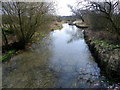
River Wylye, Longbridge Deverill
Looking upstream from Longbridge Deverill bridge.
Image: © Maigheach-gheal
Taken: 19 Mar 2011
0.19 miles
8
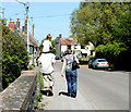
2010 : Walkers and rider, Sand Street, Longbridge Deverill
On the bridge over the River Wylye.
Image: © Maurice Pullin
Taken: 22 May 2010
0.19 miles
9
Longbridge Deverill : Road
A road to Manor Farm.
Image: © Lewis Clarke
Taken: 31 Jul 2023
0.19 miles