IMAGES TAKEN NEAR TO
Longbridge Deverill, WARMINSTER, BA12 7DG
Introduction
This page details the photographs taken nearby to BA12 7DG by members of the Geograph project.
The Geograph project started in 2005 with the aim of publishing, organising and preserving representative images for every square kilometre of Great Britain, Ireland and the Isle of Man.

There are currently over 7.5m images from over14,400 individuals and you can help contribute to the project by visiting https://www.geograph.org.uk
Image Map
Images are licensed for reuse under creativecommons.org/licenses/by-sa/2.0
Notes
- Clicking on the map will re-center to the selected point.
- The higher the marker number, the further away the image location is from the centre of the postcode.
Image Listing (45 Images Found)
Images are licensed for reuse under creativecommons.org/licenses/by-sa/2.0
Image
Details
Distance
1

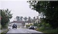
2008 : A350 to Warminster at Longbridge Deverill
As the sign says, you go left for Maiden Bradley. The road opposite goes to Sutton Veny.
Image: © Maurice Pullin
Taken: 19 Nov 2008
0.05 miles
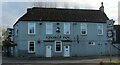
3

2008 : The George Inn, Longbridge Deverill
They have their own website http://www.thegeorgeinnlongbridgedeverill.co.uk/
Image: © Maurice Pullin
Taken: 19 Nov 2008
0.06 miles
4

The George Inn, Longbridge Deverill
Former coaching inn https://www.the-georgeinn.co.uk/
Image: © Tim Heaton
Taken: 31 Jan 2022
0.07 miles
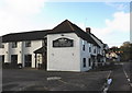
5
The George Inn, Longbridge Deverill
At the cross roads in Longbridge Deverill, on the A350. The sign depicts George IV, one our most unloved monarchs.
Image: © Chris Heaton
Taken: 31 Jan 2022
0.07 miles
6

Longbridge Deverill crossroads
Looking north along the A350 towards Warminster.
The George Inn is to the left.
Image: © Jonathan Billinger
Taken: 5 Jan 2010
0.08 miles
8

2008 : Crossroads at Longbridge Deverill
The village of Longbridge Deverill is part of the Deverill valley. This encompasses six villages on the Wiltshire Downs where the western edge of Salisbury Plain dips into Somerset. Longbridge is the principal village and its parish includes neighbouring Crockerton. The other Deverills are Hill, now in Longbridge parish, Brixton, Monkton and Kingston
.
The name Deverill refers to the River Deverill, which flows through the whole valley. It rises to the west of Kingston Deverill and flows north, passing through the six villages. At Crockerton it meets the Shearwater Stream and becomes the River Wylye. The name Deverill literally means ‘diving rill’. There are points along its route where it peters out and flows underground, hence the disappearing rill or stream.
All the above was copied from http://www.wiltshire.gov.uk/community/getcom.php?id=143 where there is much more. Very interesting.
Image: © Maurice Pullin
Taken: 19 Nov 2008
0.09 miles
9

Longbridge Deverill : Service Station
A BP and Londis on the A350.
Image: © Lewis Clarke
Taken: 31 Jul 2023
0.10 miles
10
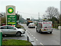
A350 south at Longbridge Deverill
Petrol prices as of the 5th day of the 2010's.
Image: © Jonathan Billinger
Taken: 5 Jan 2010
0.11 miles