IMAGES TAKEN NEAR TO
Longbridge Deverill, WARMINSTER, BA12 7DD
Introduction
This page details the photographs taken nearby to BA12 7DD by members of the Geograph project.
The Geograph project started in 2005 with the aim of publishing, organising and preserving representative images for every square kilometre of Great Britain, Ireland and the Isle of Man.

There are currently over 7.5m images from over14,400 individuals and you can help contribute to the project by visiting https://www.geograph.org.uk
Image Map
Images are licensed for reuse under creativecommons.org/licenses/by-sa/2.0
Notes
- Clicking on the map will re-center to the selected point.
- The higher the marker number, the further away the image location is from the centre of the postcode.
Image Listing (9 Images Found)
Images are licensed for reuse under creativecommons.org/licenses/by-sa/2.0
Image
Details
Distance
1
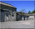
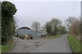
2009 : Broomclose Farm
Apparently disused.
Image: © Maurice Pullin
Taken: 2 Jun 2009
0.03 miles
2
2009 : Aircraft landed at Wing Farm
Just in time to miss him coming down.
Image: © Maurice Pullin
Taken: 2 Jun 2009
0.08 miles
3
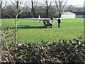
Microlight aircraft at Wing Farm
A view to the southeast towards a microlight aircraft at Wing Farm.
Image: © Phil Williams
Taken: 4 Feb 2007
0.09 miles
4
Aircraft at Wing Farm
A view looking east towards the aircraft parking area at Wing Farm.
Image: © Phil Williams
Taken: 4 Feb 2007
0.10 miles
5
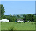
Wing Farm, Longbridge Deverill
The name reflects the farm's possession of an airstrip
Image: © Tim Heaton
Taken: 1 Feb 2022
0.11 miles
6
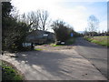
Wing Farm
A view to the southwest approaching Wing Farm at Longbridge Deverill.
Image: © Phil Williams
Taken: 4 Feb 2007
0.12 miles
7
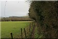
Bridleway outside Wing Farm
This is officially a bridleway heading for Brixton Deverill, but it would be certainly a challenge for horse riders on this narrow pathway - exasperated by the overhanging vegetation
Image: © Chris Heaton
Taken: 1 Feb 2022
0.13 miles
8
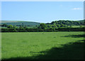
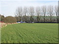
2009 : Near Wing Farm looking south
The lower slopes of Brims Down to the right, the hill on the left is Summer Down above Brixton Deverill (unseen).
Image: © Maurice Pullin
Taken: 2 Jun 2009
0.19 miles
9
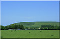
2009 : Looking east near Wing Farm
Cow Down dominates the scene with a glimpse or two of Hill Deverill between.
If you are wondering what a Deverill is, it is a family name. Anyone know anything about them?
Image: © Maurice Pullin
Taken: 2 Jun 2009
0.21 miles