IMAGES TAKEN NEAR TO
Deverill Road, WARMINSTER, BA12 7BZ
Introduction
This page details the photographs taken nearby to Deverill Road, BA12 7BZ by members of the Geograph project.
The Geograph project started in 2005 with the aim of publishing, organising and preserving representative images for every square kilometre of Great Britain, Ireland and the Isle of Man.

There are currently over 7.5m images from over14,400 individuals and you can help contribute to the project by visiting https://www.geograph.org.uk
Image Map
Images are licensed for reuse under creativecommons.org/licenses/by-sa/2.0
Notes
- Clicking on the map will re-center to the selected point.
- The higher the marker number, the further away the image location is from the centre of the postcode.
Image Listing (4 Images Found)
Images are licensed for reuse under creativecommons.org/licenses/by-sa/2.0
Image
Details
Distance
1
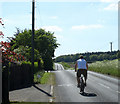
2010 : Cyclist on Deverill Road, Sutton Veny
Heading west to Longbridge Deverill.
Image: © Maurice Pullin
Taken: 22 May 2010
0.07 miles
2
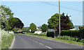
2010 : Entering Sutton Veny on Deverill Road
Image: © Maurice Pullin
Taken: 22 May 2010
0.09 miles
3
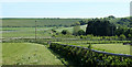
2010 : South from Deverill Road
Looking toward Whiten Hill. Longbridge Hill and Cow Down are to the right.
Image: © Maurice Pullin
Taken: 22 May 2010
0.15 miles
4
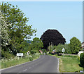
2010 : Deverill Road entering Sutton Veny
The scene is dominated by a huge copper beech.
Image: © Maurice Pullin
Taken: 22 May 2010
0.22 miles