IMAGES TAKEN NEAR TO
Sutton Veny, WARMINSTER, BA12 7BP
Introduction
This page details the photographs taken nearby to BA12 7BP by members of the Geograph project.
The Geograph project started in 2005 with the aim of publishing, organising and preserving representative images for every square kilometre of Great Britain, Ireland and the Isle of Man.

There are currently over 7.5m images from over14,400 individuals and you can help contribute to the project by visiting https://www.geograph.org.uk
Image Map
Images are licensed for reuse under creativecommons.org/licenses/by-sa/2.0
Notes
- Clicking on the map will re-center to the selected point.
- The higher the marker number, the further away the image location is from the centre of the postcode.
Image Listing (3 Images Found)
Images are licensed for reuse under creativecommons.org/licenses/by-sa/2.0
Image
Details
Distance
1
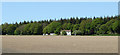
2010 : Ploughed field east of Longbridge Deverill
Standing on the bank by the side of the road to Sutton Veny. Southleigh Wood with its conifers provides the background.
Image: © Maurice Pullin
Taken: 22 May 2010
0.04 miles
2
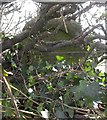
Old Milestone east of Longbridge Deverill
Stone post (plate lost) by the UC road, in parish of LONGBRIDGE DEVERILL (WEST WILTSHIRE District), Old Brickyard Farm; opposite furniture workshop, deep in hedge, on South side of road. Bruton Sun iron plate, erected by the Bruton turnpike trust in the 18th century.
Inscription once read:- : (BRUTON / 13 / Miles) :
Carved bench mark low down on face.
Milestone Society National ID: WI_BNMB13.
Image: © M Faherty
Taken: 8 Mar 2007
0.22 miles
3
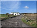
Southleigh Farm
A view looking north from the B3095 along the access road to Southleigh Farm.
Image: © Phil Williams
Taken: 21 Jan 2006
0.23 miles