IMAGES TAKEN NEAR TO
Sutton Veny, WARMINSTER, BA12 7AJ
Introduction
This page details the photographs taken nearby to BA12 7AJ by members of the Geograph project.
The Geograph project started in 2005 with the aim of publishing, organising and preserving representative images for every square kilometre of Great Britain, Ireland and the Isle of Man.

There are currently over 7.5m images from over14,400 individuals and you can help contribute to the project by visiting https://www.geograph.org.uk
Image Map
Images are licensed for reuse under creativecommons.org/licenses/by-sa/2.0
Notes
- Clicking on the map will re-center to the selected point.
- The higher the marker number, the further away the image location is from the centre of the postcode.
Image Listing (11 Images Found)
Images are licensed for reuse under creativecommons.org/licenses/by-sa/2.0
Image
Details
Distance
1
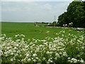
Haycombe Hill
View north over some seasonal cow parsley towards Haycombe Hill Bungalow.
Image: © Jonathan Billinger
Taken: 21 May 2008
0.04 miles
2
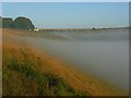
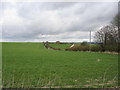
Haycombe Bottom
The upper part of the combe is a sheep-grazed pasture. Haycombe Hill Farm is beside the trees.
Image: © Andrew Smith
Taken: 25 Aug 2007
0.05 miles
3
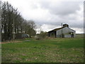
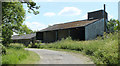
Barn at Haycombe Hill Farm
A view looking to the southeast towards a barn at Haycombe Hill Farm. The lane passing to the left of the barn is a Road Used as a Public Path (RUPP).
Image: © Phil Williams
Taken: 25 Feb 2007
0.07 miles
4
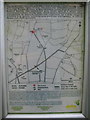
Information panel at Haycombe Hill farm
A view of the countryside access information panel at the start of the RUPP at Haycombe Hill Farm on Whiten Hill.
Image: © Phil Williams
Taken: 25 Feb 2007
0.08 miles
5
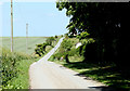
2010 : Lane on Whiten Hill
Outside Haycombe Hill Farm at the end of the lane. This way, the only way there is, to Sutton Veny.
Image: © Maurice Pullin
Taken: 21 Jun 2010
0.08 miles
6
2010 : Barn on Whiten Hill
Shown in June at a different angle from Image]
Belongs to Haycombe Hill Farm.
Image: © Maurice Pullin
Taken: 21 Jun 2010
0.10 miles
8
Whiten Hill
A view looking to the northeast across whiten hill. Haycombe Hill Bungalow can be seen in the distance.
Image: © Phil Williams
Taken: 25 Feb 2007
0.16 miles
9
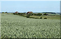
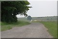
2010 : Wheatfield and bungalows on Whiten Hill
The ground to the right slopes down to Haycombe Bottom.
Image: © Maurice Pullin
Taken: 21 Jun 2010
0.17 miles
10
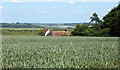
2010 : Wheat on Whiten Hill
Mostly wheat being grown in this area this year.
The roof belongs to a bungalow on the lane from Sutton Veny.
Distant hills are on the other side of the Wylye Valley.
Image: © Maurice Pullin
Taken: 21 Jun 2010
0.17 miles