IMAGES TAKEN NEAR TO
Rise Road, WARMINSTER, BA12 7AA
Introduction
This page details the photographs taken nearby to Rise Road, BA12 7AA by members of the Geograph project.
The Geograph project started in 2005 with the aim of publishing, organising and preserving representative images for every square kilometre of Great Britain, Ireland and the Isle of Man.

There are currently over 7.5m images from over14,400 individuals and you can help contribute to the project by visiting https://www.geograph.org.uk
Image Map
Images are licensed for reuse under creativecommons.org/licenses/by-sa/2.0
Notes
- Clicking on the map will re-center to the selected point.
- The higher the marker number, the further away the image location is from the centre of the postcode.
Image Listing (6 Images Found)
Images are licensed for reuse under creativecommons.org/licenses/by-sa/2.0
Image
Details
Distance
1
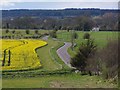
Minor road from Corton to Tytherington
Image: © David Martin
Taken: 21 Apr 2012
0.15 miles
2
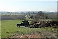
2011 : Perfectly placed pick-up pleases photographer
A stand of beech trees had been recently felled. The woodsman and his assistant (and his vehicle) were still on site, he told me they were diseased and had to go.
Between Tytherington and Corton on the minor road through the Wylye Valley.
(The trees were in poor shape as well.)
Image: © Maurice Pullin
Taken: 7 Mar 2011
0.21 miles
3
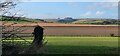
Corton, Wiltshire
Looking towards Tytherington Hill from the western edge of the village of Corton.
Image: © Rebecca A Wills
Taken: 27 Dec 2020
0.22 miles
4
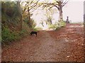
Footpath between Tytherington and Corton
Wonderful autumnal colours.
Image: © Maigheach-gheal
Taken: 4 Nov 2007
0.24 miles
5
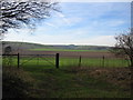
Wiltshire Farmland
A view looking to the southwest across farmland towards Tytherington Hill.
Image: © Phil Williams
Taken: 4 Feb 2007
0.25 miles
6
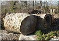
2011 : Felled beech trees near Corton
Would estimate them to be 200 to 250 years old from the size.
The woodsman was still on site, he told me they were diseased.
Image: © Maurice Pullin
Taken: 7 Mar 2011
0.25 miles