IMAGES TAKEN NEAR TO
Kilmington, WARMINSTER, BA12 6RP
Introduction
This page details the photographs taken nearby to BA12 6RP by members of the Geograph project.
The Geograph project started in 2005 with the aim of publishing, organising and preserving representative images for every square kilometre of Great Britain, Ireland and the Isle of Man.

There are currently over 7.5m images from over14,400 individuals and you can help contribute to the project by visiting https://www.geograph.org.uk
Image Map
Images are licensed for reuse under creativecommons.org/licenses/by-sa/2.0
Notes
- Clicking on the map will re-center to the selected point.
- The higher the marker number, the further away the image location is from the centre of the postcode.
Image Listing (6 Images Found)
Images are licensed for reuse under creativecommons.org/licenses/by-sa/2.0
Image
Details
Distance
1
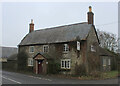
Red Lion Inn on the B3092
The public house had the air of permanent closure on our visit.
Image: © Chris Heaton
Taken: 1 Feb 2022
0.09 miles
2
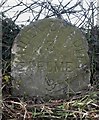
Old Milestone by the B3092, Frome Road, Stourton with Gasper
Carved stone post by the B3092, in parish of STOURTON WITH GASPER (SALISBURY District), Frome Road; 100m South of the Red Lion, opposite lay-by, in hedgerow, on West side of road. Frome stone, erected by the Frome turnpike trust in the 19th century.
Inscription reads:- : MAIDEN BRADLEY / 3 / FROME / 9 :
Milestone Society National ID: WI_MYFR03.
Image: © M Faherty
Taken: 1 Mar 2007
0.09 miles
3

The Red Lion Inn
According to https://whatpub.com/pubs/WSX/87/red-lion-inn-kilmington "This pub is long-term Closed. Did not reopen after winter 2021 lockdown." The vegetation on the walls suggest it has been closed much longer than that.
Image: © Tim Heaton
Taken: 1 Feb 2022
0.11 miles
4

White Sheet Lane
A view looking northeast along the B3092 towards the junction with the single track lane leading to White Sheet Hill, at right between the Red lion public house and the red car.
Image: © Phil Williams
Taken: 19 Mar 2006
0.11 miles
5
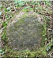
Old Milestone by Long Lane, Kilmington
Carved stone post by the UC road, in parish of STOURTON WITH GASPER (SALISBURY District), Long Lane, Kilmington; 250m West of junction with the B3092 at the Red Lion, on South side of track. Erected by an unknown authority in the 19th century.
Inscription once read:-
Salisbury
24
Milestone Society National ID: WI_SAOD24.
Image: © M Faherty
Taken: 27 Feb 2007
0.16 miles
6
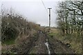
The east end of Long Lane
Forewarning of a soggy tramp along this near one mile sunken lane? Fortunately, later sections were drier.
Image: © Tim Heaton
Taken: 1 Feb 2022
0.18 miles