IMAGES TAKEN NEAR TO
Kilmington, WARMINSTER, BA12 6RH
Introduction
This page details the photographs taken nearby to BA12 6RH by members of the Geograph project.
The Geograph project started in 2005 with the aim of publishing, organising and preserving representative images for every square kilometre of Great Britain, Ireland and the Isle of Man.

There are currently over 7.5m images from over14,400 individuals and you can help contribute to the project by visiting https://www.geograph.org.uk
Image Map
Images are licensed for reuse under creativecommons.org/licenses/by-sa/2.0
Notes
- Clicking on the map will re-center to the selected point.
- The higher the marker number, the further away the image location is from the centre of the postcode.
Image Listing (11 Images Found)
Images are licensed for reuse under creativecommons.org/licenses/by-sa/2.0
Image
Details
Distance
1
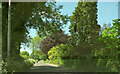
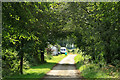
New Road, Kilmington
A straight stretch of road, seen looking in the other direction in Image
Image: © Derek Harper
Taken: 27 May 2022
0.07 miles
2
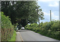
2012 : New Road near Kilmington
Looking south to Kilmington Common and Stourton.
Image: © Maurice Pullin
Taken: 14 Aug 2012
0.08 miles
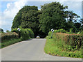
3
2012 : Butts Lane, Kilmington
Heads north east through Kilmington without seeing much of it, passes a Dead Woman and a few farms, ends up at Maiden Bradley after just over three miles. not very exciting.
An American butt is a different thing from one of ours.
Image: © Maurice Pullin
Taken: 14 Aug 2012
0.10 miles
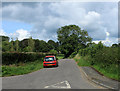
4
2012 : North on New Road near Kilmington
Toward Yarnfield Gate, Gare Hill and Trudoxhill.
The signs indicate the end of the 30mph speed limit through Kilmington.
Image: © Maurice Pullin
Taken: 14 Aug 2012
0.12 miles
5
2012 : Green Ride Cottages
A bridleway heading away from Kilmington to Tower Road and on to Alfred's Tower.
Two Jack Russells emerged from the cottage and ran toward me barking furiously, then they realized I was bigger than them and ran away.
Image: © Maurice Pullin
Taken: 14 Aug 2012
0.12 miles
6
St. Marys, Kilmington
A view looking northeast to St Marys church.
Image: © Phil Williams
Taken: 19 Mar 2006
0.19 miles
7
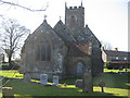
St. Marys, Kilmington
A view looking west across the graveyard at St. Marys church, Kilmington.
Image: © Phil Williams
Taken: 19 Mar 2006
0.19 miles
8
War Memorial, Kilmington: late August 2016
Image: © Basher Eyre
Taken: 26 Aug 2016
0.20 miles
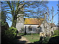
9
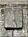
Sundial, St Mary's Church
The sundial is on the south wall of the church.
Sundials or sun clocks are considered to be the oldest known device for the measurement of time and one of the most ancient scientific instruments.
The oldest known true sundial was built around 1500BC in Egypt. Shaped like a letter 'L' the length of the shadow cast by the vertical leg along the horizontal leg indicated the time. The Romans perfected the horizontal sundial we know today and invented portable travelling versions.
Image: © Maigheach-gheal
Taken: 19 Mar 2011
0.24 miles
10

St Mary the Virgin, Kilmington: late August 2016
Image: © Basher Eyre
Taken: 26 Aug 2016
0.25 miles