IMAGES TAKEN NEAR TO
Kilmington Common, WARMINSTER, BA12 6QU
Introduction
This page details the photographs taken nearby to Kilmington Common, BA12 6QU by members of the Geograph project.
The Geograph project started in 2005 with the aim of publishing, organising and preserving representative images for every square kilometre of Great Britain, Ireland and the Isle of Man.

There are currently over 7.5m images from over14,400 individuals and you can help contribute to the project by visiting https://www.geograph.org.uk
Image Map
Images are licensed for reuse under creativecommons.org/licenses/by-sa/2.0
Notes
- Clicking on the map will re-center to the selected point.
- The higher the marker number, the further away the image location is from the centre of the postcode.
Image Listing (2 Images Found)
Images are licensed for reuse under creativecommons.org/licenses/by-sa/2.0
Image
Details
Distance
1
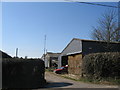
GB3WA at Great Ground Farm
A view looking west across New Road to Great Ground Farm. The aerials on the mast on the middle barn form part of the GB3WA and GB3WX amateur radio repeaters. See http://www.ukrepeater.net/gb3wa.htm for more details.
Image: © Phil Williams
Taken: 19 Mar 2006
0.06 miles
2
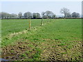
Pasture near Kilmington
Small pasture fields are divided by barbed wire.
In 1874 Joseph F Glidden, a sixty year old farmer from Illinois, invented and patented barbed wire. It has also been called the Devil's Rope or the Devil's Hatband.
Image: © Maigheach-gheal
Taken: 19 Mar 2011
0.20 miles