IMAGES TAKEN NEAR TO
Stourton, WARMINSTER, BA12 6QQ
Introduction
This page details the photographs taken nearby to BA12 6QQ by members of the Geograph project.
The Geograph project started in 2005 with the aim of publishing, organising and preserving representative images for every square kilometre of Great Britain, Ireland and the Isle of Man.

There are currently over 7.5m images from over14,400 individuals and you can help contribute to the project by visiting https://www.geograph.org.uk
Image Map
Images are licensed for reuse under creativecommons.org/licenses/by-sa/2.0
Notes
- Clicking on the map will re-center to the selected point.
- The higher the marker number, the further away the image location is from the centre of the postcode.
Image Listing (4 Images Found)
Images are licensed for reuse under creativecommons.org/licenses/by-sa/2.0
Image
Details
Distance
1
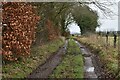
Bridleway on track south of Search Farm
Image: © David Martin
Taken: 4 Feb 2023
0.04 miles
2
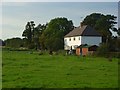
Cottages, Search Farm, Stourton
The cottages catch some weak evening sunshine in a view from the bridleway to the south.
Image: © Andrew Smith
Taken: 13 Sep 2008
0.05 miles
3
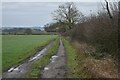
Bridleway to Mere, south of Search Farm
Image is directly in line with the right hand hedge.
Image: © David Martin
Taken: 4 Feb 2023
0.11 miles
4
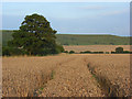
Farmland, Stourton
A field of wheat awaits harvesting beneath the slopes of White Sheet Hill.
Image: © Andrew Smith
Taken: 13 Sep 2008
0.18 miles