IMAGES TAKEN NEAR TO
Top Lane, WARMINSTER, BA12 6QA
Introduction
This page details the photographs taken nearby to Top Lane, BA12 6QA by members of the Geograph project.
The Geograph project started in 2005 with the aim of publishing, organising and preserving representative images for every square kilometre of Great Britain, Ireland and the Isle of Man.

There are currently over 7.5m images from over14,400 individuals and you can help contribute to the project by visiting https://www.geograph.org.uk
Image Map
Images are licensed for reuse under creativecommons.org/licenses/by-sa/2.0
Notes
- Clicking on the map will re-center to the selected point.
- The higher the marker number, the further away the image location is from the centre of the postcode.
Image Listing (4 Images Found)
Images are licensed for reuse under creativecommons.org/licenses/by-sa/2.0
Image
Details
Distance
1
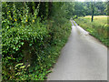
A lane into the estate
The view is along Top Lane, which is in the Stourhead estate. There is a benchmark on the left which took some effort to free from the undergrowth. The wall mentioned in the OS description (see Image) is actually the lower parapet over the stream connecting the various ornamental lakes – the headwaters of the River Stour.
Image: © Neville Goodman
Taken: 16 Aug 2021
0.19 miles
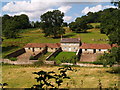
2
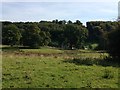
Farm in Stour Valley, Gasper
This farm has been a fascination for me for years. It reminds me of the model farms we had as children, very self contained and in this case, quite unspoilt.
Image: © James Harrison
Taken: 29 Sep 2015
0.21 miles
4
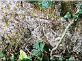
Benchmark freed from nettles and ivy
Once the ivy, nettles, brambles, moss and various other bits and pieces had been scraped aside Image, the benchmark (NBM WALL SW SIDE TOP LANE NE FACE E ANG) was revealed as remarkably undamaged.
Image: © Neville Goodman
Taken: 16 Aug 2021
0.23 miles