IMAGES TAKEN NEAR TO
Gasper, Stourton, WARMINSTER, BA12 6PZ
Introduction
This page details the photographs taken nearby to BA12 6PZ by members of the Geograph project.
The Geograph project started in 2005 with the aim of publishing, organising and preserving representative images for every square kilometre of Great Britain, Ireland and the Isle of Man.

There are currently over 7.5m images from over14,400 individuals and you can help contribute to the project by visiting https://www.geograph.org.uk
Image Map
Images are licensed for reuse under creativecommons.org/licenses/by-sa/2.0
Notes
- Clicking on the map will re-center to the selected point.
- The higher the marker number, the further away the image location is from the centre of the postcode.
Image Listing (11 Images Found)
Images are licensed for reuse under creativecommons.org/licenses/by-sa/2.0
Image
Details
Distance
1

Telephone box near Stourton
K6 style telephone kiosk in the very corner of the square.
Image: © Maigheach-gheal
Taken: 1 Feb 2009
0.01 miles
2

Telephone box above New Lake
Remarkably, a telephone box that appears to still contain a functioning telephone.
Image: © David Martin
Taken: 3 Feb 2023
0.02 miles
3

Gasper: postbox № BA12 79 and phone
Two red objects just about as far into the corner of a gridsquare as it is possible to get. A pleasant autumnal view is spread out beyond them.
Image: © Chris Downer
Taken: 24 Oct 2010
0.03 miles
4

The road to Gasper
Finger post road sign at T junction.
Image: © Chris McAuley
Taken: 20 Aug 2013
0.03 miles

6

New Lake, Stourton
This is one of the medieval fishponds which were transformed into more formal lakes. This one, extended in the 19th Century, was remade yet again after its dam was destroyed as the result of a huge storm in 1917.
Image: © Maigheach-gheal
Taken: 1 Feb 2009
0.09 miles
7

New Lake
Seen from Gasper Street, which crosses the dam.
Image: © Robin Webster
Taken: 2 Apr 2017
0.11 miles
8

New Lake, Stourton
This is one of the medieval fishponds which were transformed into more formal lakes. This one, extended in the 19th Century, was remade yet again after its dam was destroyed as the result of a huge storm in 1917.
Image: © Maigheach-gheal
Taken: 1 Feb 2009
0.12 miles
9

New Lake
A view looking to the northeast across the southern end of New Lake.
Image: © Phil Williams
Taken: 16 Jun 2006
0.13 miles
10
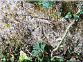
Benchmark freed from nettles and ivy
Once the ivy, nettles, brambles, moss and various other bits and pieces had been scraped aside Image, the benchmark (NBM WALL SW SIDE TOP LANE NE FACE E ANG) was revealed as remarkably undamaged.
Image: © Neville Goodman
Taken: 16 Aug 2021
0.20 miles