IMAGES TAKEN NEAR TO
Zeals Rise, WARMINSTER, BA12 6PL
Introduction
This page details the photographs taken nearby to Zeals Rise, BA12 6PL by members of the Geograph project.
The Geograph project started in 2005 with the aim of publishing, organising and preserving representative images for every square kilometre of Great Britain, Ireland and the Isle of Man.

There are currently over 7.5m images from over14,400 individuals and you can help contribute to the project by visiting https://www.geograph.org.uk
Image Map
Images are licensed for reuse under creativecommons.org/licenses/by-sa/2.0
Notes
- Clicking on the map will re-center to the selected point.
- The higher the marker number, the further away the image location is from the centre of the postcode.
Image Listing (87 Images Found)
Images are licensed for reuse under creativecommons.org/licenses/by-sa/2.0
Image
Details
Distance
1
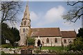
Zeals
St Martin's Church, Zeals, Wiltshire. Zeals is noteworthy for being one of the very rare places in the UK beginning with the letter Z.
Image: © Brendan and Ruth McCartney
Taken: 24 Apr 2005
0.11 miles
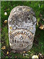
2
Milestone, Zeals
Late 18th century limestone pillar with cast iron plate. The road was turnpiked 1754-56.
Turnpikes were administered by turnpike trusts, which were authorised by private act of parliament. The trusts laid down a network of soundly constructed roads throughout the country, replacing parochial maintenance system on many highways and substantially improving communications. The first English turnpike roads were authorised by an act of 1663. By the 1800s there were about 8000 toll-gates and 22,000 miles of highway. The trusts engineers, notably John Macadam, constructed many new roads, which by the 1800s were being utilized by an efficient stagecoach system. However, railway expansion after 1830 led to the rapid decline of stagecoaches and turnpike revenue.
Turnpike roads were built by private enterprise under licence from the Government and maintained by tolls on those who used them.
Image: © Maigheach-gheal
Taken: 26 Nov 2010
0.14 miles
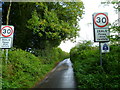
3
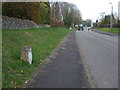
Milestone in Zeals
A quiet road now that the Bourton Bypass is in full flow. See Image] for a closer look.
Image: © Neil Owen
Taken: 6 Mar 2020
0.14 miles
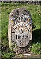
4
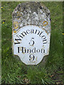
Nine miles to Hindon
A milestone in Zeals. See Image] for a wider view on New Road.
Image: © Neil Owen
Taken: 6 Mar 2020
0.14 miles
5
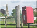
Zeals: postbox № BA12 95, Portnell?s Lane
A standard lamp box serving the Westfield Estate, mounted on a metal pole but standing alongside a wooden post which may well once have had the box strapped to it. The spire of the Image is in the background.
Image: © Chris Downer
Taken: 30 Jun 2014
0.14 miles
6
Old Milestone by New Road, Zeals
Metal plate attached to stone post by the UC road, in parish of ZEALS (SALISBURY District), New Road, 200m West of junction with Bricknells Lane, on grass bank, on West side of road. Wincanton iron plate, erected by the Wincanton turnpike trust in the 18th century.
Inscription reads:-
Wincanton
5
Hindon
9
Grade II listed.
List Entry Number: 1283236 https://historicengland.org.uk/listing/the-list/list-entry/1283236
Milestone Society National ID: WI_WCHD05.
Image: © M Faherty
Taken: 1 Mar 2007
0.14 miles
7
Milestone, Zeals
The raised lettering reads Wincanton / 5 / Hindon / 9. For a wider view of the stone Image
Milestones did not come into general use until the Turnpike Act of 1766 made them compulsory on turnpike roads, these roads were built by private enterprise under licence from the Government and maintained by tolls on those who used them. Before this Act milestones were put up occasionally, often as charitable acts and commemorations. Many Turnpike Act stones still exist. They are usually 2-3 ft high, with the initial letter or abbreviation of the nearest market town show on two faces, and the distance from it.
Image: © Maigheach-gheal
Taken: 26 Nov 2010
0.14 miles
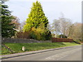
8
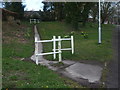
A path to Tulse Hill
The white barriers seem somewhat superfluous if they are installed to stop wheeled traffic.
Image: © Neil Owen
Taken: 6 Mar 2020
0.15 miles
9
The Orange Way in Wiltshire (1)
The Orange Way is a long distance path of 341 miles following the route of William of Orange from his landing at Brixham to St James's Palace in London. I started the walk in October 2011 and have passed through Torbay, Devon, Dorset and Somerset. I now embark on the continuation through Wiltshire. Here the Orange Way approaches Zeals up Tulse Hill.
Image: © Shazz
Taken: 26 Sep 2012
0.16 miles
10

Bench Mark, St Martin's Church
The Ordnance Survey bench mark is to be found on the south west of the church tower. For a wider view of the church Image and for further information on the bench mark http://www.bench-marks.org.uk/bm36098
Image: © Maigheach-gheal
Taken: 26 Nov 2010
0.16 miles