IMAGES TAKEN NEAR TO
St. Martins Close, WARMINSTER, BA12 6NU
Introduction
This page details the photographs taken nearby to St. Martins Close, BA12 6NU by members of the Geograph project.
The Geograph project started in 2005 with the aim of publishing, organising and preserving representative images for every square kilometre of Great Britain, Ireland and the Isle of Man.

There are currently over 7.5m images from over14,400 individuals and you can help contribute to the project by visiting https://www.geograph.org.uk
Image Map
Images are licensed for reuse under creativecommons.org/licenses/by-sa/2.0
Notes
- Clicking on the map will re-center to the selected point.
- The higher the marker number, the further away the image location is from the centre of the postcode.
Image Listing (71 Images Found)
Images are licensed for reuse under creativecommons.org/licenses/by-sa/2.0
Image
Details
Distance
1
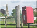
Zeals: postbox № BA12 95, Portnell?s Lane
A standard lamp box serving the Westfield Estate, mounted on a metal pole but standing alongside a wooden post which may well once have had the box strapped to it. The spire of the Image is in the background.
Image: © Chris Downer
Taken: 30 Jun 2014
0.16 miles
2

St Martin's Church, Zeals
The church was designed by Messers Scott and Moffat and was built of local stone with dressings of Bath stone. The church was consecrated on October 14th 1846.
Image: © Maigheach-gheal
Taken: 26 Nov 2010
0.20 miles


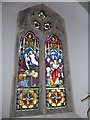
6
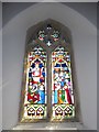
St Martin, Zeals: stained glass window (4)
Image: © Basher Eyre
Taken: 26 Aug 2016
0.20 miles
7

Ordnance Survey Cut Mark
This OS cut mark can be found on the SW face of St Martin's Church. It marks a point 146.1708m above mean sea level.
Image: © Adrian Dust
Taken: 19 Nov 2014
0.20 miles
8

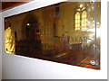
Bench Mark, St Martin's Church
The Ordnance Survey bench mark is to be found on the south west of the church tower. For a wider view of the church Image and for further information on the bench mark http://www.bench-marks.org.uk/bm36098
Image: © Maigheach-gheal
Taken: 26 Nov 2010
0.20 miles
9
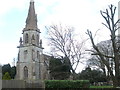
St Martin's, Zeals
The village has some recorded notation of a chapel in the thirteenth century as well as other places of worship in the sixteenth, but there appears to be no trace of wither today. However, as the village grew in the nineteenth, it was decided to apply for a church to be built here. The landowner, the Duke of Somerset, agreed to allow work to commence and some £3,000 was raised. The designers were Messers Scott (George Gilbert Scott, no less!) and Moffat and the church was consecrated on October 14th, 1846.
By 27th June, 1848, Zeals was made a separate ecclesiastical parish from Mere and so this church became the focal point of the village. In 1876 Julia Chafyn Grove (a local benefactor) provided funds for a spire to be added, as well as many interior fittings and improvements.
Image: © Neil Owen
Taken: 6 Mar 2020
0.20 miles
10
St Martin, Zeals: stained glass window (1)
Image: © Basher Eyre
Taken: 26 Aug 2016
0.20 miles