IMAGES TAKEN NEAR TO
Chapel Lane, WARMINSTER, BA12 6NR
Introduction
This page details the photographs taken nearby to Chapel Lane, BA12 6NR by members of the Geograph project.
The Geograph project started in 2005 with the aim of publishing, organising and preserving representative images for every square kilometre of Great Britain, Ireland and the Isle of Man.

There are currently over 7.5m images from over14,400 individuals and you can help contribute to the project by visiting https://www.geograph.org.uk
Image Map
Images are licensed for reuse under creativecommons.org/licenses/by-sa/2.0
Notes
- Clicking on the map will re-center to the selected point.
- The higher the marker number, the further away the image location is from the centre of the postcode.
Image Listing (1 Images Found)
Images are licensed for reuse under creativecommons.org/licenses/by-sa/2.0
Image
Details
Distance
1
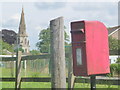
Zeals: postbox № BA12 95, Portnell?s Lane
A standard lamp box serving the Westfield Estate, mounted on a metal pole but standing alongside a wooden post which may well once have had the box strapped to it. The spire of the Image is in the background.
Image: © Chris Downer
Taken: 30 Jun 2014
0.19 miles