IMAGES TAKEN NEAR TO
Zeals, WARMINSTER, BA12 6NE
Introduction
This page details the photographs taken nearby to BA12 6NE by members of the Geograph project.
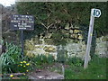
The Geograph project started in 2005 with the aim of publishing, organising and preserving representative images for every square kilometre of Great Britain, Ireland and the Isle of Man.

There are currently over 7.5m images from over14,400 individuals and you can help contribute to the project by visiting https://www.geograph.org.uk
Image Map
Images are licensed for reuse under creativecommons.org/licenses/by-sa/2.0
Notes
- Clicking on the map will re-center to the selected point.
- The higher the marker number, the further away the image location is from the centre of the postcode.
Image Listing (30 Images Found)
Images are licensed for reuse under creativecommons.org/licenses/by-sa/2.0
Image
Details
Distance
1
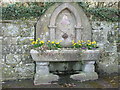
A drink in Zeals
This fine two-tiered drinking fountain is installed on New Road. It was a gift to the village by Julia Chafyn Grove (wife of the lawyer and politician William) in 1875. Zeals did not have a public water supply until it was piped from Mere in 1938.
Image: © Neil Owen
Taken: 6 Mar 2020
0.02 miles
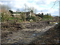
2
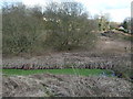
The beds see daylight for the first time for about twenty years
Zeals used to have a small but useful watercress industry in this area by Fantley Lane. Having been abandoned to Nature for a couple of decades and now just cleared, an original bed can be seen again.
Image: © Neil Owen
Taken: 6 Mar 2020
0.04 miles
3
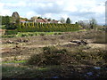
Uncovering the old beds
This area of Zeals used to be used for watercress beds. They were started in the nineteenth century (as were others in the general area) as a small industry in the village. Crops were cut and dispatched to Gillingham train station. However, the trade dwindled and shortly after WWII the approximately 3.78 acres site was abandoned. Having laid untouched for over twenty years, the diggers have moved in to clear the vegetation in order for a land sale.
Image: © Neil Owen
Taken: 6 Mar 2020
0.07 miles
4
No horses or cycles!
An old cast notice prohibits four-legged or wheeled use of the footpath.
Image: © Neil Owen
Taken: 6 Mar 2020
0.07 miles
5
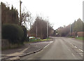
Up the hill from Bourton to Zeals
The road is also the border between Wiltshire and Dorset, and hence the nearest buildings are Border Cottages. A close look by the drainpipe reveals a softened benchmark - see Image
Image: © Neil Owen
Taken: 6 Mar 2020
0.09 miles
6
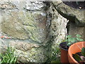
Benchmark on Border Cottage
Standing very close to the border between Wiltshire and Dorset is a well-weathered benchmark. The two boundaries are pretty close to the junction with Somerset too. See https://www.bench-marks.org.uk/bm48465 for the entry in the Benchmark Database and Image] for a wider view.
Image: © Neil Owen
Taken: 6 Mar 2020
0.09 miles
7
A fresh bed
The land at the junction of New Road and Fantley Lane was once used for allotments. Recent clearances have altered the landscape quite significantly.
Image: © Neil Owen
Taken: 6 Mar 2020
0.09 miles
8
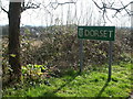
A border sign in Zeals
The county boundary sign is positioned here, although the actual place might be a little bit further away.
Image: © Neil Owen
Taken: 6 Mar 2020
0.12 miles
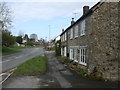
9
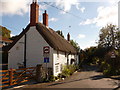
Zeals: cottages in Fantley Lane
An attractive pair of cottages just into Fantley Lane off the main road.
Image: © Chris Downer
Taken: 24 Oct 2010
0.14 miles